 |
Ros
Davies'
Co. Down, Northern Ireland Family History Research Site © Rosalind Davies 2001 Permission granted to reprint research for non-profit use only |
 |
Place Names of Co. Down: K.....
| Ka....... | Ke....-Kid... | Kilb....... | Kill....... | Killy....... | Kilm....... | Kin....... | Kir....... | Knock....... | Know- Ky |
| Place Name | Parish | Map Ref | Information | |
| Kargagh Ban | Donaghmore | . | alternate spelling for Cargabane townland in 1829 |
IIW V 4p119
|
| Karmakully | Newry | . | alternate spelling for Carnacally townland in Bagenal rent Roll of 1575 |
PNNI V1 p 11
|
| Karnav Gar | Newtownards | . | alternate name for Cairngaver; highest hill in the area; site of Scrabo Towe |
PNNI V2 p 236
|
| Karny | Ballytrustan | . | alternate spelling for Kearny townland in 1659 census |
PNNI V2 p 61
|
| Kary Hill Cary Hill |
Down | . | on the banks of the Quoile River; residence of the Perceval- Price family in late 19th century & Michael Perceval in 1936; photo available |
WAG p22 ; SHM '90 p 16; DR* 28/9/36
|
| Kates Bridge | Bright | 21: 49/39 | over a stream in Whigamstown townland | . |
| Katesbridge | Drumballyroney | 20: 20/41 | a village in Ballybrick townland, 7km N of Rathfriland; bridge over river Bann; named after Kate McKay; click here for a photo and more information | . |
| Katherine Quay | Ballyculter | . | private harbour near Old Court; built by Lord de Ros in 1844; photo available | LWAG p 43 ; LM 1989 p38; Inv 2014 p10 |
| Kay Cottage | Kilcoo | . | a house in Newcastle; residence of Arthur Rooney in 1910 |
POD
|
| Keans Bridge | Clonduff | . | wkm SW of Hilltown | old b/w map D11 |
| Ballytrustan | 21: 65/52 | a townland of 236 acres; 4km ENE of Portaferry; click here to see its location on a townland map; means' area of the angular rocks'; in 1659 there were 17 English/Scots & 9 Catholic families here; coal ship aground, 2 drowned 30 Dec 1797; let in perpetuity to Rev. Mr. Blacker of Markethill in 1836 ; average rent then was £27.13.10; potatoes, wheat & barley; school established 1822: the average rent in 1836 was £27 a year; it was let in perpetuity to Rev. S. Blacker; lrge mill here; shipwreck sale 10 Dec 1842: shipwreck 28 Feb 1846: shipwreck 15 Dec 1849; wreck of German barque "Adler" 20 Jan 1877;SS Strathure ashore 10 Feb 1883 | NS; V7 p 8, 15 & V17 p 124, 127, 128 OSM; SP; : DR; PNNI V2 p 61, 63; JUAHS p14 & 2011 p20 | |
| Kearney's Hill | Bangor |
15:56/82
|
part of Portavie Estate; 2km SE of Groomsport |
PNNI V2 p 174
|
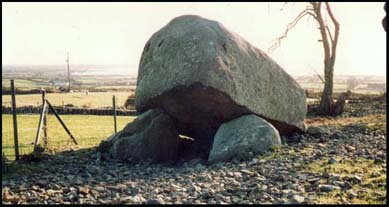
| Pat Kearney's Big Stone | Clonduff | 29: 24/23 | also known as Goward dolmen or Cloughmore Cromlech; click here for a photo |
HMNI p89; IPP p 106
|
| Kearney's Town | Ardglass | . | farm; 2km N of Ardglass town |
old b/w map O16
|
| Kearneystown | Garvaghy | . | a cluster of houses in Tullyorier townland; 6km SE of Banbridge |
old b/w map G7; PNNI V6 p 208
|
| Keeghan's Bridge | Donaghcloney | 20: 12/57 | or Geehan's Bridge; over River Lagan 3km NE of Waringstown | . |
| Keele | Dromore | . | spelling used for Ballykeel townland in 1659 census |
PNNI V6 p111
|
| Keel Point | Kilmegan | . | on the inner harbour of Dundrum Bay; bridge built connecting Murlough with Keel Point Sep 1858 |
old b/w map K14; WDG p11,12,218
|
| Keelan Lake | Kilclief | . | lake; 2km W of Kilclief village |
old b/w map Q16
|
| Keelstown | Inch | . | a house cluster near Downpatrick; residence of John Bassett in 1840 & Charles Seay in 1851 & H. Cargo & Son in 1910 |
PR; POD
|
| Keentagh Kintagh |
Ballyphilip or Witter | . | on the coast, 4km SE of Portaferry town; click here to see its location on a townland map; means ' the fair house'; held by John Fitzsymon in 1578; in 1659 there were 0 English/Scots & 4 Catholic families here; the lowest rent in 1836 was 30 shillings and the highest 35 shillings a year |
PNNI V2 p 130;SP; V7 p 7 OSM
|
| Keerinan | Tullylish | . | spelling for Kernan townland in 1659 census |
PNNI V6 p 341
|
| Kelles country | Comber & Tullynakill | . | a district name in ancient times ; named after Kelly families originally from Drumbo |
LR 2005 p15
|
| Kellys Close | Kilcoo | . | 1km N of Kilcoo village |
old b/w map H12
|
| Kelly's Lough | Loughinisland | 21: 40/49 | 1km NE of Drumaness village in Drumnaconnor townland; also known as Ram Lough & Pollramer Lough | BH ; PE |
| Keltonstown | Kilmegan | 20: 33/42 | 5km N of Castlewellan | . |
| Kelvinville | Dundonald | . | residence of F.A. Owens in 1902 | POD |
| Kemp Stones | Newtownards | 21: 44/74 | ancient chambered grave in Greengraves townland , 4km E of Dundonald; b/w photo available |
PNNI V2 p 230 ; TMUOP p28, 29
|
| Kenles Kenlys |
Kilclief | . | name of an ancient Catholic church in Killard townland | O'L V1 p 181,192; LM 1994 p58 |
| Kenles | Loughinisland | . | site of an ancient chapel in 1615 & Mass Rock gatherings here during the penal period | LCB p 16; O'L B p 323 |
| Kennedys Hill | Donaghadee | 21; 55/73 | hill near Ballyblack townland, 4km NW of Grey Abbey town |
PNNI V2 p 196
|
| Kennedys Hill | Drumballyroney | 29: 23/37 | 3km SW of Ballyward; in Lackan townland |
old b/w map G10; PNNI V6 p 183
|
| Kennedy Park | Clonallan | 29: 15/21 | farm, 2km N of Warrenpoint | . |
| Kennedy's Quay | Holywood | . | in Belfast Lough; in Holywood village |
V7 p 83 OSM
|
| Kennedy Villa | Donaghmore | 20: 9/37 | farm, 6km S of Loughbrickland | . |
| Kennel Bridge | Knockbreda | . | over a stream just NW of Stormont Castle | old b/w map S5 |
| Kenoge | Donaghcloney | . | a hamlet in Annaghanoon townland in 1609 |
PNNI V6 p 85
|
| Kensington Villa | Bangor | . | villa on the west side of Bangor Bay; built in 1890 for John Neill | OS map 1902 2 .05 |
| Kensington Villa | Bangor | . | residence of William Carson in 1886 | POD |
| Kensington | Knockbreda | . | house & garden of 1 acre in Knock townland ,leased by John Dickson in 1863 from Alexander Dickson |
GV; OS map 1902 5.09
|
| Kensington Villa | Knockbreda | . | villa in Kings Rd, East Belfast next door to Kensington (above) in 1902 |
OS map 1902 5.09
|
| Kentagher -Killydressy | Ballyphilip | . | see Keentagh | V17 p 125 OSM |
| Keonan | Donaghcloney | 20: 12/51 | farm, 4km S of Donaghcloney town | . |
| Kernal Lough | Ballyphilip | 21: 59/52 | small lake in grounds of Portaferry House | . |
| Kernan | Tullylish | . | a townland 2km S of Tullylish village ; 749 acres; click here to see its location on a townland map; means ' rowan tree'; hill 423 ft; lakes; proprietor A. R. Stewart Esq. & Earl Clanwilliam; 3 mills in 1836 | V12 p140,142, 143, 144,146 OSM; old b/w map G5' PNNI V6 p 340 |
| Kernan House | Tullylish | . | residence of Thomas Lockhart in 1910 |
POD
|
| Kernan Lake | Tullylish | 20: 8/47 | 3km S of Tullylish townin Kernan townland; site of massace in Mar 1641 of 80 Protestant settlers who were drowned by soldiers under Capt. Phelim Art McBrian whilst travelling from Co Armagh |
BCT p 18; PNNI V6 p 341
|
|
Kerney & |
Ballytrustan | . | alternate spelling for Kearney townland in 1830 | PNNI V2 p 61 |
| Kerrs Bridge | Moira | 20: 11/62 | over the railway line, 4km W of Moira | . |
| Kerrs Close | Kilmood | . | farm; 2km S of Comber |
old b/w map Q8
|
| Kerrstown | Ballyphilip | . | near Portaferry |
DCPH p 98
|
| Kerrs Bridge | Kilclief | . | near Kerr's Corner, & Kilclief National School |
Inv 2000 p 29
|
| Kerr's River | Kilcoo | . | ancient name for the Shimna River which runs through Newcastle | WDG p111 |
| Ker's Villa | Donaghadee | . | house & 4acres in Townparks townland;leased by rep. Edward Leslie in 1863 | GV |
| Kesh Bridge | Blaris | 20: 22/60 | in Aghnatrisk townland; 3km NW of Hillsborough town | . |
| Keskane Keskum |
Aghaderg | . | alternate spelling for Caskum townland | PNNI V6 p 29 |
| Kessenan | Tullylish | . | alternate name for Kernan townland on Rent Roll 1692 | PNNI V6 p 341 |
| Keyhill | Clonduff | . | alternate name for Kinghill townland in 1777 | PNNI V3 p 89 |
| Kidds Corner | Kilcoo | . | at the corner of Tollymore Road & Newcastle Road |
PTTF p17
|
| Kidds Town | Donaghmore | . | farm; 10km NE of Newry town | old b/w map D8 |
| Kielle | - | . | ancient name for Lecale district | O'L B p 153 |
| Kilandress | Killyleagh | . | alternate name for Killaresy | O'L V1 p 332 |
| Kilbeg | Down | . | ancient name for Ballykilbeg townland |
LR 2005 p24
|
| Kilbogland | Magheralin | . | 4 acres of land in Ballynadrone held by Coslet Waddell in 1868 | PNNI V6 p 228 |
| Kilbride | Bright | 21: 53/36 | a townland 1km S of Killough town; click here to see its location on a townland map; means ' Bridget's church'; site of an ancient Catholic church by 1622 it was a ruin; granted to Richard Fitz-Richard who died 1629; proprietor Lord Bangor in 1836 | V17 p 34, 35 OSM;O'L V1 p 154, 157 , 201; LR 2005 p25; WDG p234 |
| Kilbright | Donaghadee | 21: 60/72 | a townland 2km W of the coast; 4km S of near Millisle; 232 acres; click here to see its location on a townland map; means church of the variegated place'; in 1659 there were 6 English/Scots & 1 Catholic families here; owned by Sir William G. Johnson in 1863 | V17 p 124 OSM; SP; PNNI V2 p 192; GV |
| Kilbroney | Kilbroney | . | parish & townland of 575 acres; borders on Carlingford Lough; click here to see its location on a townland map; means ' Bronach's church'; town of Rostrevor is here; proprietor David Ross Esq., of the Lodge in 1836; bleach green here in 1836 & 1886; ancient standing stone here; bleach greens owned by Henry Dunn & R. & D. Martin here in 1910 | V3 p 28, 32 OSM; PNNI V1 p 132; IPP p 109; POD |
| Kilbroney House | Kilbroney | . | 1km NE of Rostrevor; built by architect Thomas Duff in 1830s for Martin family |
old b/w map C12; Perspective V7 p7
|
| Kilbroney Red Bog | Kilbroney | 29: 21/22 | in The Mournes near Rostrevor Forest | . |
| Kilbroney River | Kilbroney | 29: 19/20 | rises in the Mournes and flows south to Rostrevor | . |
| Kilbroney Upper | Kilbroney | 29: 19/23 | a townland of 1068 acres;on the slopes of the Mournes, 4km N of Rostrevor between The Ghann & Kilbroney rivers; click here to see its location on a townland map | V3 p 26 OSM |
| Kilbulk | Loughinisland | . | near Ballyrolly & Ballykilbeg; site old an ancient Catholic chapel | LCB p 16; O'L V1 p 90; LM 1994 p58 |
| Kilburn | Donaghadee | . | villa in Warren Rd, Donaghdee; residence of Misses Hamilton in 1910 | POD |
|
Kilcairn |
Killinchy | . | in Drumreagh townland; north side of Saintfield/ Killinchy road;site of an old graveyard, mostly Catholic; gravestone inscriptions UHF Vol 5; oldest stone 1757 |
V5 MIs
|
| Kilclief | Kilclief | 21: 59/45 | a parish, a small village & a townland of 623 acres; 10 km E of Downpatrick on the coast; click here to see its location on a townland map; means ' church of wattle or timber church'; owned by Archdeacons of Down in ancient times but leased by Nicholas Fitsimmonds in 1622; very old church & castle; mill here in 1836 ; school here in 1836; Bishops land £40 in 1744; history lecture 9 Mar 1850: Col. Leslie Estate fire 24 May 1851; concert & amateur theatricals 14 Feb 1880; old story about monks who worked the mill , reprinted 6 Oct 1999 | V17 p 78, 118 OSM ;DR:HMNI p104; O'L V1 p 208 & B p 319; LR 2005 p27 |
| Kilclief Castle | Kilclief | . | Norman Castle near the Church of Ireland; Mr. Armor resident in 1792; click here for a photo |
NS
|
| Kilclief Cottage | Kilclief | . | near the castle , office & farm to be sold 27 Oct 1849: |
DR
|
| Kilclief Point | Kilclief | 21: 60/46 | at the entrance to Strangford Lough near Kilclief Castle | . |
| Kilconemie | Drumballyroney | . | spelling used for Kilkinamurray townland in 1659 census | PNNI V6 p 199 |
| Kilcoo Kilcowe |
Kilcoo | 29: 28/33 | a village and a parish; 6km SW of Castlewellan on Rathfriland road; means 'church of St. Cua' or ' church of the hollow'; the village is in Ballymoney townland; Catholic church here ; in 1765 there were 345 Protestants & 1510 Catholics in the parish; generous gift from landlord, Lord Bangor 18 Jan 1879; destitute poor 21 Feb 1880 | V3 p 41-45 OSM; O'L v1 p 38 & B p 323; DR ; PNNI V3 p 97, 101, 117 |
| Kilcooley | Bangor | 15:49/80 | now on the SW outskirts of Bangor town | . |
| Kildares Crew | Ballee | . | just NW of Killough; click here to see its location on a townland map ; owned by Major Beauclerk in 1836 ; there were 5 families here needing famine relief in 1847; owned by Aubrey de Vere Beauclerk in 1863; article 5 Feb 1869 | V17 p 20,22 OSM; GV ; FCD S2 p 25 |
| Kildownie Moat | Dundonald | . | in Dunlady townland; a hill & stream | TMUOP p50 |
| Kildroichid | Ardkeen | . | name of an ancient church near Lisbane | O'L V1 p 425 |
| Kileen | Holywood | . | residence of William Dobbin in 1870 | PR |
| Kilfarran | Dromore | . | alternate name for Killysorrell townland in 1659 Census | PNNI V6 p 132 |
| Kilfeaghan | Kilbroney | 29: 22/17 | a townland 4km E of Rostrevor on the slopes of The Mournes; 298 acres; click here to see its location on a townland map;means ' Fiachan's church'; originally belonged to Sir Art Magennis in 1611; cromlech/dolmen -Giants Grave; proprietor David Ross Esq., Lodge in 1836; | V3 p29, 32, 39 OSM; CM:HMNI p89 ; PNNI V1 p 144 |
| Kilfeaghan Upper | Kilbroney | . | a townland of 517 acres; click here to see its location on a townland map; | . |
| Kilfullert Kilfolard |
Magheralin | 20: 13/56 | a townland 4km S of Magheralin; 131 acres; click here to see its location on a townland map ; means ' wood of the cooking place'; owned by Sir Art Magennis in 1609 |
PNNI V6 p 242
|
| Kilhorne | Kilkeel | near Annalong; old graveyard here; school here |
UHF V10
|
|
| Kilhorne Bay | Kilkeel | 29: 37/19 | in the Irish Sea 1km SW of Annalong | . |
| Kiliscolban | Dromore | . | spelling used for Skillyscolban townland in 1659 census | PNNI V6 p 141 |
| Kilkahyll | Kilkeel | . | alternate spelling for Kilkeel in 1527 | PNNI V1 p 119 |
| Kilkeel | Kilkeel | 29: 31/14 | a parish, a townland of 554 acres & a town (in Magheramurphy townland) on the Irish Sea, near the mouth of Carlingford Lough; click here for a map of the townlands in this parish; means either Caol's church or church of the narrow place'; click here for some photos and more information | . |
| Kilkeel Bay | Kilkeel | 29: 31/13 | in Irish Sea, long bay near Kilkeel town | . |
| Kilkeel House | Kilkeel | 29: 30/16 | farm, 2km NW of Kilkeel | . |
| Kilkeel River | Kilkeel | 29: 32/37 | runs north to Slieve Corragh; a mill was set up here by the Walmsley family from England c. 1790s |
PNNI V3 p 181 ; MO 12/8/2009 p30
|
| Kilkeeran | Killinchy | . | anceint name for Kilcairn ; old Catholic graveyard | V5 MIs |
| Kilkeeran | Kilmore | . | ancient church site | KCB p 4 |
| Kilkinamurry Kilknamurry |
Garvaghy | 20: 23/44 | in SW foothills of Dromara Hills; 1174 acres ;click here to see its location on a townland map;means wood of Murchadh's hound'; Covenanters/ Presbyterian church built 1821; also called The Glen Meeting house here; school here in1836 | V12 p 79, 80, 81, 84 OSM ; PNNI V6 p 199: GIC |
| Killaghy | Donaghadee | 15:57/76 | 2km W of Millisle; 984 acres; in the western part of the parish; has a hill 143 feet above sea level, a bog and a small pond; school erected in 1829 |
V7 p 45 ,50 OSM
|
| Killaghy | Shankill | . | in the southern part of the parish | V12 p 138 OSM |
| Killaire | Bangor | . | alternate spelling for Ballykillare townland in 1659 census | PNNI V2 p 154 |
| Killaire House | Bangor | . | in Ballykillare townland; leased by Samuel Davidson family in 1887-1895 from Capt. A.M. Henderson; staff photo c. 1890 available |
TMUOPp 48,123
|
| Killandress | Kilmore | . | alternate name for Killaresy | . |
| Killaneeny | Saul | . | a clachan in Carrowcarlin townland | PR |
|
Killaney Killany |
Killaney | . | a small parish & townland of 298 acres; west of Saintfield; click here to see its location on a townland map ;its ancient name was Anaghdoloun; means " the Church surrounded by the marshes"; site of an ancient church & graveyard run by abbots of Movilla; tithes of fish granted to Lord Clandeboy in 1629; well forested in 1625; in 1659 there were 2 Catholic families living here but mainly settled by Scots families; the proprietor in 1836 was Lord Downshire whose agent was Mr Reilly of Hillsborough; in 1837 there were 15 farms from 3-26 acres with the average being 10 acres ;rents from 28- 32 shillings an acre; good quality land ; attack on minister 1837: farming society 5 Aug 1843; Church of Ireland & 3 Presbyterian churches here & a general graveyard | SHM '86 p 32 & '98 p 78,79 ; V 17 p 133 & V 7 p 120 OSM; V 7 p 123 OSM ; DR; GIPR; GIC; O'L V1 p 372, 373 |
| Killaney Lodge | Killaney | . | residence of Mr. W.J. Price J.P. 3 Jul 1924 | DR* |
| Killaney | Garvaghy | 20: 19/46 | a townland 3km SW of Garvaghy village; 524 acres; click here to see its location on a townland map; means ' ivy covered church'; belonged to the Bishop of Dromore; site of an ancient Catholic chapel, graveyard & St. Patrick's Stone, used as old Mass Rock; standing stones near flow bog |
PNNI V6 p 200, 201; V 12 p 81 OSM; KCB p 4
|
| Killaney House | Garvaghy | . | 2-3 kms. SWof Tullyglush & 1-2 kms. SW of Garvaghy Hill; residence of Thomas Henry Stronge & Rev. Albert Ernest Samuel Stronge | Phil Strong |
| Killanure | Saintfield | . | see under Killinure | . |
|
Killand |
Ballyculter then Kilclief |
21: 59/43 | a townland 6km S of Strangford town, on the coast; formerly in Ballyculter parish but added to Kilclief in 1834; owned by Lord De Ros in 1836 ;shipping accident 29 Sep 1849; story about smugglers in 1800; photo available; 'Hearts of Down' Gaelic Athletics Association begun 1903 | NS; V17 p 30, 31 OSM; LWAG p46; DR; DR* 9/4/28R; MO 5/03 |
| Killare | Bangor | . | alternate name for Ballykillare townland in Rental roll 1681 |
PNNI V2 p 154
|
| Killard Point | Kilclief | 21: 61/44 | rocky point near Killard townland; wreck of 'SSRL Alston' at Killard Point 31 Jan 1885; author Michael McLavery retired here and wrote about the area c. 1940 |
DR ; LR 2004 p26+
|
| Killaresy | Killyleagh | 21: 51/57 | a townland 4km NW of Killyleagh on Killinchy road; in Toye townland; name of an ancient church; in 1704 Rev Patrick Moylin was parish priest; a general graveyard here & Mass rock | KCB p 4, 5, 25; V17 p 83 OSM; GIC; O'L V1 p 332, 345 |
| Killarn Killarneid |
Newtownards | 15:44/75 |
a townland 3km NW of Newtonards town;412 acres; click
here to see its location on a townland map; means
' Earnan's church' or 'church of the sloes'; site of a Catholic chapel
in 1615; in 1659 there were 4 English/Scots & 0 Catholic families
here & the proprietor was David Kennedy Esq.; there was a bleach
mill here in 1836
|
O'L B p 326; V7 p 110 OSM;SP; PNNI V2 p 231;TMUOP p232 |
| Killaughey Killaghy |
Donaghadee | . | a townland 4km SW of Donaghadee town; click here to see its location on a townland map; means ' church of the field';ancient graveyard here; Samuel Atcheson's farm sold 16 Jun 1792 (NS) ; H. McKee invokes Tenants Rights against landlord V.E. Knox 9 Jan 1874 (DR); Mr E. Knox & his tenantry, dinner 29 Jun 1889; sale of Killaughey estate 5 Sep 1891; new National School 12 Nov 1898 (NC) | NS; V17 p 124 OSM; DR; NC; PNNI V2 p 193 |
| Killavees | Down | . | a townland 2km NE of Downpatrick; 98 acres; click here to see its location on a townland map;site of an ancient Catholic chapel; owned by the Southwell Estate in 1752 & leased to William Mercer Esq. ; owned by heirs of Lord De Clifford; with proprietor Lord De Clifford in 1836; dry soil; near Downpatrick race-course; proprietor Mr Ferguson c. 1870 | V17 p 53 ,57 OSM; LM 1991 p25; O'L B p 141, 322 & O'L V1 p 253 |
| Killclosh | Kilclief | . | alternate spelling for Kilclief parish in 1704 |
O'L B p 503
|
| Killcoman | Newtownards | . | alternate name for Scrabo townland in 1675 | PNNI V2 p 236 |
| Killconain | Kilmore | in Cluntagh townland; name of an ancient Catholic chapel, graveyard & well | KCB p 24; O'L V1 p 331 | |
| Killdownie House | Dundonald | 15:42/76 | farm; 2km N of Dundonald village | . |
| Killeany | Garvaghy | see Killany | V12 p 81 OSM | |
|
Killearn |
Dundonald- part | 15:39/76 | 2km NW of Dundonald village; 32 acres; means ' the little glen'; the proprietor in 1837 was Rev. Cleland; land quality middling; farms from 3-20 acres; rent 25 shillings an acre; crops were potatoes, oats & barley;article on scutch mill 8 Jul 1876 | V7 p 40, 65 OSM; TMUOP p231; DR ; |
|
Killeen Cottage |
Dundonald | . | residence of David Morrison in 1902 | POD |
| Killeavey | Slanes | . | farm house in Ballyfinragh townland |
old b/w map U16
|
| Killeen Killarn |
Holywood- part | 15:39/76 | a townland 3km S of Holywood; 137 acres; click here to see its location on a townland map; means ' the little glen'; the proprietor in 1837 was Mr McGill of Dromore; in 1834 there were 17 houses with 9 families employed in agriculture & 3 in trade; 30 males & 38 females; 4 servants, 4 in handicrafts |
V7 p 40 ,77, 79 OSM
|
| Killeen Cottage | Holywood | . | house & farm of 42 acres in Killeen townland; ;leased by David Morrison in 1863 from John Cleland | GV ; old b/w map R5 |
| Killeen House | Holywood | . | house off Ballymiscaw Road | Q6/19 CBSA |
| Killenaken |
Killinchy
|
. | see Killinakin | . |
| Killenanaghe Killenena |
. | . | or Ballinegrange; ancient townland in 17th century in East Down; owned by Earl of Ardglass in 1669 & leased to Cromwell Ward Esq | LM 1985 p52; V17 p 123 OSM |
| Killenaterny | Grey Abbey | . | alternate spelling for Kilnatierny townland in 1830 | V17 123 OSM; PNNI V2 p 208 |
| Killengar | Newtownards | . | alternate name for Kiltonga townland in 1627 | PNNI V2 p 232 |
| Killeniner | Saintfield | . | see Killanure | . |
| Killenny | Killaney | . | ancient name of Killaney ;just W of Saintfield | . |
| Killeny | Garvaghy | . | spelling for Killaney townland in Subsidy Roll of 1663 | PNNI V6 p 201 |
| Killernard | Bright | . |
name of ancient Catholic chapel at St. John's Point
|
O'L V1 p 181 |
| Killerny | Newtownards | . |
alternate spelling for Killarn townland in 1659 census
|
PNNI V2 p 231 |
| Killeshanan | Donaghmore | . |
alternate name for Killysavan townland in 1659 census
|
PNNI V1 p 101 |
| Killevalgin | Grey Abbey | . |
see Killyvolgan
|
V17 p 124 OSM |
| Killevy Castle | Newry | . | near Camlough in Co. Armagh part; residence of Powell Foxall J.P. in 1846 & 1881 |
POD
|
| Killeleyney | Donaghcloney | . | a hamlet in Corcoreeny townland in 1609 |
PNNI V6 p 91
|
| Killeloman | Donaghcloney | . | in the south of Corcrreny townland |
PNNI V6 p 91
|
| Killfarane | Donaghmore | . | alternate name for Killysavan townland on Rent Roll of 1692 |
PNNI v1 p 101
|
| Killiany | Garvaghy | . | spelling for Killaney townland in will of 1720 |
PNNI V6 p 201
|
| Killiemure | Saintfield | . | ancient name for Killinure townland |
SP:SHM '94 p56
|
| Killinakin | Killinchy | . | a townland 2km NE of Killinchy town, on Strangford Lough; 214 acres;click here to see its location on a townland map; a general graveyard is here |
V7p 86 OSM ; GIC
|
| Killinchy | Killinchy |
21:50/61
|
a parish & a town & townland of 555 acres;click here to see its location on a townland map; means 'church of St. Duinseach'; click here for photos and more information | . |
| Killinchy in the Woods | Killyleagh | . | a townland 6km W of Killyleagh town; click here to see its location on a townland map; 988 acres; bought by Ker family before 1780; an ancient church & graveyard here on the site of the school house; great destitution 20 Mar 1847: incendiarism 23 Feb 1850: Sabbath school 16 Dec 1837: soiree, teachers 26 Dec 1853; Sabbath school presentations 14 Nov 1857 | DR* 3/12/03 ; TCC p 33; DR; O'L V1 p 330 |
| Killiney Villa | Bangor | . | in Crawfordsburn Rd, Bangor; residence of G. Absolom in 1901 | POD |
| Killinney | Garvaghy | . | alternate spelling for Killaney townland in wills of 1841 | PNNI V6 p 201 |
| Killinore Cottage | Magheralin | . | farm; near River Lagan; 4km NNW of Magheralin village |
old b/w map J2
|
| Killinure Killimeure Killanure Killynures |
Saintfield | 20: 36/64 | a townland of 770 acres; click here to see its location on a townland map; 2km S of Carryduff on the Ballynahinch road; in 1659 there were 2 English/Scots & 4 Catholic families living here; school here; in 1837 there were 65 houses; 176 males & 201 females; best quality land; farms from 20-40 acres; rents from 20-30 shillings an acre; the proprietor then was Mr Price of Saintfield |
V7 p 118 OSM ; SP: SHM '94 p56 & '86 p 32
|
| Killips Court | Holywood | . | a row of 12 house in High St,Holywood owned by Thomas Killips in 1863 | GV |
| Killiscolban | Dromore | . | alternate spelling for Skillyscolban townland in 1760 | IIW V4 p34 |
| Killivolgan | Greyabbey | . | alternate spelling for Killyvolgan townland in 1659 census | PNNI V2 p 207 |
| Killkelly | Drumballyroney | . | alternate spelling used for Tirkelly townland in 1659 census | PNNI V6 p 177 |
| Killmanagh | Greyabbey | . | alternate name for Ballygrangee townland in 1662 | PNNI V2 p 204 |
| Killmeans | Kilmore | . | name of an old Mass Rock & church | KCB p 4 |
| Killmologe | Kilkeel | . | see under Kilmologe | . |
| Killnagarrick | Saintfield | . | local name of an ancient church in Tonaghmore townland which burnt down in 1641; means ' church of the rocks' | SHM '94 p37,39; O'L V1 p 372 & B p 324 |
| Killnahattin | .Kilkeel | . | ancient name for an old Catholic church of St. Mary's in Ballaghanery, in ruins since 17th century | O'L V1 p 29; PNNI V3 p 60 |
| Killough | Rathmullan then Bright | 21: 53/36 | town & townland of 422 acres 7km SE of Downpatrick ;click here for a photo and more information ; click here to see its location on a townland map; means 'church of the lough' | . |
| Killough Bridge | Ardglass | 21: 53/38 | over water where Strand Lough meets Killough Harbour | . |
| Killough Harbour | Ardglass | 21: 54/37 | large harbour between Killough & Ardglass |
V17 p 34 OSM
|
| Killowne Killowen |
Killyleagh | . | near Killyleagh Castle; name of an ancient Catholic chapel; means ' river church'; chance meeting of Lady Dufferin & Phelim Magennis produced the song The Irish Emigrant c. 1840s | KCB p 24; O'L V1 p 331; LM 1994 p46-49 |
| Killowen | Kilbroney | 29: 18/15 | on Carlingford Lough, 2km SE of Rostrevor; means ' river church'; an old territorial name which contained 7 townlands, Ballinran, Ballyneddan, Ballyedmond, Ballincurry, Ballindoalty, Ballintur & Tamnyveagh; owned by Donal & James McYawnie in 1568 then given to Lord Nicholas Bagenal 1690s & then owned by Bishops of Dromore; school here in 1836 :farming society 19 Feb 1842; Seafield House, home of Charles Russel, Lord Chief Justice of England in 1894; email me for an old photo | V3 p 38 OSM:MS WAG p 74; PNNI V6 p 12; MO 5/8/ 2009 p6; OFN p 201 |
| Killowen Mountains | Kilbroney | . | 666 acres; a new townland; click here to see its location on a townland map |
PNNI V1 p 146
|
| Killowen Point | Kilbroney | 29: 18/15 | juts out into Carlingford Lough 2km SE of Rostrevor; owned by Lord Nicholas Bagenal in 1690s |
MO 5/8/ 2009 p6 .
|
| Killrasy | Killyleagh | . | see under Killarasy | . |
| Killsarran Killsoakan |
Dromore | . | alternate spellings for Killysorrell townland on Rent Rolls of 1692 | PNNI V6 p 132 |
| Killtariff | Drumgath | . | see Kiltariff | V3 p 21 OSM |
| Killultagh | Blaris | . | parish works program held in the manor in 1836; it was one of Lord Hertford's manor houses and estates | V12 p 32, 39,42 OSM |
| Killvey | Loughinisland | . | means the deers church | LCB p 81 |
| Killy Andrews | Killyleagh | . | alternate name for Killlarasy | . |
| Killyargin |
Kilclief
|
. | name of a field which was the site of an ancient Catholic chapel in Ballywooden townland |
O'L V1 p 203
|
| Killybawn |
Kilmore
|
. | name of an ancient Catholic chapel & graveyard in Barnamaghery townland; also called Killyman |
MIs
|
| Killyclough | Loughinisland | . | ancient name for a Catholic church & cemetery in Farranfad |
O'L V1 p 90
|
| Killydressy | Ballyphilip or Witter | . | a townland 2km SE of Portaferry town; click here to see its location on a townland map ; means ' brambly quarter'; all rents were 35 shillings a year in 1836; proprietor in 1836 was Andrew Nugent; all rents above 22 shillings a quarter; leases 3 lives or 31 years; a small stream runs through it |
V7 p 7, 8, 125 OSM; PNNI V2 p 131
|
| Killygarten | Kilmore | . | old Mass Rock where Catholic worshipped in penal times & ancient graveyard | KCB p 4; O'L V1 p 329 |
| Killglais | Kilmore | . | name of an ancient church possibly in Clontaghnaglar | O'L V1 p 330 |
| Killyglinnie | Ballykinler | . | site of an ancient Catholic church & graveyard in Upper Ballykinler; also called Parkaneety | O'L V1 p 125, 227 |
| Killygoney | Magheradrool | 20: 37/55 | old cemetery;means wood of the Conies or church of the Conies; 3km N of Ballynahinch on the Saintfield road; the proprietor in 1795 was John Magee | BH ; UJA |
| Killyhoran | Kilkeel | . | means 'church of the cold spring well'; the site of an ancient church in Moneydarraghmore townland |
O'L V1 p 28; PNNI V3 p 60
|
| Killy in the Woods | Killyleagh | . | see Killinchy in the Woods | . |
| Killyleagh | Killyleagh | 21:53/53 | a town & a parish; click here for a map of the townlands; means 'church of the descendants of Laoch'; click here for a photo and more information | . |
| Killyleagh Castle | Killyleagh | . | 12th century Norman castle;belongs to the Hamilton family; : click here for a photo and more information | . |
| Killylone | Kilmore | . | ancient name for a Pre Reformation Catholic church in Magheralone townland | O'L V1 p 92 |
| Killyman | Kilmore | . | old Mass Rock & chapel & graveyard in Barnamaghery townland ; also called Killybawn | KCB p 4,24; MIs; O'L V1 p 329, 330 |
| Killyneeny Killeneeny |
Saul | . | a house cluster in Carrowcarlin townland; owned by Thomas Cromwell, Earl of Ardglass in 1662 & the Southwell Estate in 1752 |
PE; O'L V1 p 237; LM 1991 p26
|
| Killynether | Comber | 21: 47/72 | a townland 3km NE of Comber; 151 acres;click here to see its location on a townland map; the proprietor in 1837 was Capt. McIllreath whose agent was Mr Black; farms of bad quality 3-40 acres; rents were 30-40 shillings an acre; 33 males & 34 females in 1837; National School here in 1863 |
V7 p 39, 42 OSM ; GV
|
| Killynether House/Castle | Comber | . | house & farm of 25 acres, click here for a photo and more information. |
.
|
| Killynure | Saintfield | . | see under Killinure | . |
| Killysavin | Donaghmore | . | a townland of 581 acres; click here to see its location on a townland map; means ' wood of the savin bush '; originally owned by Magennis clan; ancient wall, the Danes Cast here ; 60 acres of bog; proprietor General Meade in 1836 | V17 p 130 & V3 p 8, 9 OSM; PNNI V1 p 101 |
| Killysavin Villa | Donaghmore | 29: 7/39 | 2km E of Poyntz Pass & the Co Armagh border | . |
| Killyscolban | Dromore | . | alternate spelling for Skillyscolban townland | IIW V4 p42 |
| Killysorrell | Dromore | . |
a townland 3km SW of Dromore town;
231 acres; click
here to see its location on a townland map; means ' wood
of the wire- worms'; school here in 1817 & 1836
|
V12 p 73 OSM; HSSS; PNNI V6 p 132 |
| Killysorrell House |
Dromore
|
. | residence of Susan Scott c. 1700 |
DR 23/1/1869Hanna
|
| Killysuggan |
Newtownards
|
. | site of an old church in Milecross townland & Catholic graveyard |
V5 MI
|
| Killyvees | Down | . | alternate spelling for Killavees townland |
.
|
| Killyvolgan Killyvalgan |
Grey Abbey | 21: 61/67 | a townland 3km SE of Grey Abbey; 322 acres; click here to see its location on a townland map ; means ' central wood' ; in 1659 there were 4 English/Scots & 2 Catholic families here |
PNNI V2 p 207 ; SP
|
| Killywoolpa | Ballykinler | . | site of an anicnet Catholic chapel in Lower Ballykinler | O'L V1 p 121 |
| Kilmacrew Kilmacrane |
Magherally | 20: 17/47 | a townland 6km S of Dromore; 586 acres; click here to see its location on a townland map; means ' McGreevy's wood'; fort on highest hill; originally belonged to Bishop of Dromore; Green bog here | V12 p 112, 114, 115 OSM; PNNI V6 p 264 |
| Kilmacrew House | Magherally | 20: 17/48 | farm; 2km NE of Magherally village | . |
| Kilmacrew Lodge | Magherally | . | farm;residence of Richard Coulter Culley Esq. in 1894 |
MIs
|
| Kilmainham | Castleboy | . | name of Royal Military Hospital which belonged to St. John Hospitalliers c. 1300; also the name of a jail in Dublin | O'L V1 p 412 |
| Kilmalock | Ballyculter | . | name of an ancient chapel, St. Malacy's, near parish church | O'L V1 p 192 |
| Kilmanagh | Grey Abbey | . | or Ballygrange; Ancient townland in 17th century in East Down | V17 p 123 OSM |
| Kilmegan | Kilmegan | a parish ; the town of Castlewellan is in this parish;school here in 1836;soiree 23 Aug 1851; Earl Annesley & his tenants, list of those in deputation 7 Jun 1879; Earl Annesley tries to resolve rent dispute 15 Jan 1881 | V12 p 101 & V3 p 55-60 OSM; DR; O'L B p 323 | |
| Kilmeloge Kilmologe |
Kilkeel | 29: 34/18 | site of ancient church of St. Luan; 2km N of Ballymartin village |
O'L V1 p 25,26 ; PNNI V3 p 60
|
| Kilminioge Kilminoge Kilmonyoge |
Moira | 20: 13/62 | a townland 2km WNW of Moira; click here to see its location on a townland map; means My little Finn's church'; originally belonged to O'Lavery clan; proprietor Sir R. Bateson in 1836 ; | V12 p 120 OSM; PNNI V6 p 288 |
|
Kilmood & Ballybunden |
Kilmood | 21: 46/63 | a parish & a townland of 921 acres;4km NW of Killinchy; click here to see its location on a townland map; total population of the parish in 1831 was 2,220 people with 60 linen weavers;most families in the parish were Protestant; in the townland in 1831 there were 16 houses; 12 families were employed in agriculture & 3 in trade; 58 males & 58 females; 1 professional man; 2 servants;the proprietor then was Lord Londonderry whose agent was Mr J. Andrews of Comber; good land;farms were from 10- 30 acres; crops were potatoes, wheat & oats; Church of Ireland here; one school established 1822; cattle show 12 Aug 1837: farming society 21 Jan 1843; Ulster Protestant Defence Association meeting 13 Jun 1868 (DR); Farming Society annual show 24 Jul 1875 (NC) | V7 p 94, 95, 96 OSM; DR; V 5 MI; GIPR; NC |
| Kilmore Kilmore- moran |
Kilmore | 21: 44/51 | a village, a townland of 149 acres & a parish; 6km NW of Downpatrick; click here to see its location on a map; means ' the great church'; owned by Sir Hugh Motngomery in 1615; in 1659 there were 39 English/Scots & 25 Catholic families here; school exams 13 Jun 1796 & 5 Dec 1796 & 19 Dec 1796; politcal meeting of all inhabitants 7 Oct 1796; there is a Church of Ireland, Presbyterian & Catholic chapel in the village; Glebe House; Crossgar House; school erected 1828; population in 1821 was 252; Bishops land £30 in 1744: 8 Jul 1837; effects of the Big Storm 12 Jan 1839; Poor Law district population was 3381 in 30 Nov 1839; sale of townland to Dr. Denvir in 1853: Sabbath School: Tractarianisn in parish 13 Dec 1845 & 4 Apr 1846 +: Puseyism 31 Jan 1846: opening of Protestant hall 13 Mar 1852: to be sold 29 Oct 1853; renovation of Orange Hall 3 Jun 1876; | SP: NS; SHM '94 p55; V17 p 88, 91, 92, 116, 118 OSM: BH; DR*: DR ; GIPR; TCC p 33; O'L V1 p 329 & B p 320, 323 |
| Kilmore House | Moira | . | residence of John Macoun J.P. in 1893 | BWN |
| Kilmore | Shankill | . | a townland of 1514 acres; click here to see its location on a townland map ; hill 149 ft above sea level;owned by Sir Art Magennis in 1609 then assigned to Edward Trevor; mill pond, 3 mills & canal here in 1836; proprietor C. Brownlow Esq. J. Hancock agent in 1836; this is the only townland in Shankill parish in Co Down | V12 p138, 139 OSM; PNNI V6 p 12 |
| Kilmorey Arms Hotel | Kilkeel | . | in Greencastle St, Kilkeel; opened by John Shannon 8 Feb 1845; auction of furniture as Mr. John Shannon retiring 16 Oct 1866; proprietor in 1876 was Samuel Woods & in 1910 was Miss Crory |
Newry Telegraph; POD
|
| Kilmorey House | Kilkeel | . | the proprietor in 1795 was Viscount Kilmorey; residence of Charles Beech in 1819 |
UJA; POD
|
| Kilnagreinan | Kilkeel | . | means 'church of the sunny spot' ; a pre-Reformation church in ruins in Cranfield townland |
JMLSG 2010 p14-22
|
| Kilnamurry | Garvaghy | . | alternate spelling for Kilkinamurry townland |
.
|
| Kilnatierny | Grey Abbey | . | a townland just N of Greyabbey town, on the shores of Strangford Lough; 122 acres; click here to see its location on a townland map; means ' the lord's little wood' ; in 1659 there were 3 English/ Scots families & no Catholics here |
PNNI V2 p 207.;SP
|
| Kilnburn | Donaghadee | . | house & 2 acres in Townparks townland;leased by Robert Hamilton in 1863 from Daniel Delacherois | GV |
| Kilnolgan | Greyabbey | . | possibly Killyvolgan; belongeg to St. Johns Hospitalliers |
O'L V1 p 413
|
| Kilntown | Dromore | 20: 18/55 | small village, 2km NW of Dromore | . |
| Kiln View Cottage | Moira | . | residence of J.E. Hull in 1910 |
POD
|
| Kilpatrick | Seapatrick | . | ancient name for Kilpike townland in 1659 census | PNNI V6 p 316 |
| Kilpike | Seapatrick | 20: 12/48 | a townland 3km N of Banbridge; 468 acres; click here to see its location on a townland map; owner Lord Dungannon; leased to T.M. James Esq.in 1836; Glebe House here ; bleach mills here ; murder M. Potts 27 Jan 1844; site of pre Reformation church here; a general graveyard here | V12 p124, 126, 132, 134 OSM; GIC; DDPP 124 |
| Kilracan Fort | Donaghmore | . | near Glenn Chapel; site of Mass Station in Penal times c. 1700s |
DDPP p36
|
| Kilrasy | Killyleagh | 21: 51/57 | see Killaresy | . |
| Kilscalan Kilschaelyn Kilsaghlyn |
Saintfield | . | name of an ancient church of St. Caelan in 1633 | O'L V1 p 345 & B p 27 |
| Kilsorrel | Dromore | . | see Killysorrell | . |
|
Kiltariff |
Drumgath | . | a townland just SW of Rathfriland ; click here to see its location on a townland map;means 'wood of the bulls'; belonged to Sir Arthur Magennis in 1611; the proprietor was General Meade in 1836; farms were from 4-20 acres; old leases were 16 shillings an acre & new leases 30 shillings an acre; | V3 p 21 OSM; PNNI V1 p 122 |
| Kiltarriff Hall | Drumgath | 29: 18/33 | 1km SW of Rathfriland; a stone battle axe found here |
IPP p 19
|
| Kiltonga | Newtownards | 15:48/74 | an local area name now on the western outskirts of Newtownards town; means' church on the tongue of land'; site of an ancient ecclesiastical site; Bradshaw's bleach green here 30 May 1874; curling at Kiltonga Dam 22 Jan 1881; scutching exhibition at Johnston's 20 Aug 1887 ; curling match 16 Feb 1895; acetylene gas lighting 6 Jan 1900 | NC; PNNI V2 p 232; TMUOP p130 |
| Kilschaelyn Kilsaghlyn |
Bright | . | named of an ancient Catholic church & graveyard in Ballynoe townland; area owned by Janico 'Artois in 1427 | O'L V1 p 141,142 |
| Kiltoughers | Bright | . | alternate name for Ballynoe townland c. 1749 | O'L V1 p 142 |
| Kilwarlin |
Hillsborough |
. | 4km SW of Hillsborough town; a large district in 1575 held by Rory Magennis & manor here in 1641; a new parish; also see Corcreeny townland; Church of Ireland, Moravian & Catholic churches here; Sabbath school 31 Dec 1836: seat of the Marquis of Downshire 21 Oct 1837: new church St Johns 4 May 1839: meeting of tenantry 2 Mar 1850: Catholic Parochial House; Farming Society 15 Aug 1863; meeting of tenants 1 May 1869; opening of Orange Hall 8 Nov 1879; Kilwarlin Cottage here | V12 p 68,99 OSM; UHF V18; old b/w map K5; PNNI V6 p 12, 13;LR 2005 p 12 |
| Kilwarlin House | Hillsborough | . | residence of Henry S. McClintock in 1886 & anthony F. Maude in 1910 | POD |
| Kilwarlin Cottage | Moira | . | the proprietor in 1795 was Rev. D.lM. McMullon | UJA |
| Kilwarlin Lighthouse | Slanes | . | built on South Rock in the Irish Sea in 1797; named in honour of the 2nd Marquis of Downshire; 66 foot high | PNNI V2 p 119, 120 |
| Kinallen | Dromore | 20: 25/60 | a village & townland ;4km W of Dromara;660 acres; click here to see its location on a townland map; means ' the beautiful headland'; part of the ancient district of Kilwarlin; hill 628 ft here ; mill in 1836 ; river Lagan runs through: slander & poison 7 Dec 1844; Kinallen Hill Head Farm here | V12 p 70,72,73 OSM: DR; PNNI V6 p 133 |
| Kinder House | Bright | . | in Killough; near Nannie's Sound on the coast | KCP p 74 |
| Kinedar | Bangor | . | villa in Southwell Rd, Bangor; residence of John McMeekan in 1901 |
POD
|
|
Kinedar House
|
Holywood
|
.
|
at Sydenham Ave , Strandtown ; residence of Sir Otto
Jaffe in 1902
|
POD
|
| Kinelarty | . | . | a Barony ; originally Cenel- fagartaig , the ancient territory of the Clanna Rury; takes in Loughinisland, Kilmore, Magheradrool and Magherahamlet parishes; originally owned by McCartan clan then Edward Cromwell who sold then to Matthew Forde of Seaforde in 1636 | WDG p224; PNNI V2 p xviii; Irish News 7/1/2008 p14; |
| Kings Arms | Donaghadee | . | an inn in Shore St, Donaghadee; the proprietor in 1846 was James Kelly |
POD
|
| Kings Arms | Kilbroney | . | an inn in Rostrevor; proprietor in 1846 was Elizabeth Moffatt |
POD
|
| King's Arms | Newry | . | in Hill St, Newry;also a posting house; proprietor in 1824 was Thomas Davies |
POD
|
| King's Arms | Newtownards | . | an inn in Newtownards;proprietor in 1824 was Alexander Wallace |
POD
|
| King's Arms | Saintfield | . | in Bridge St, Saintfield; proprietor in 1811 was Thomas Clark | POD |
| King's Arms Inn | Warrenpoint | . | also a posting house; proprietor in 1824 was Hugh Cunningham |
POD
|
| King's Bridge Halt | Inch | . | railway station between Crossgar & Downpatrick | NWAG p 37- map |
| King's Castle- old | Ardglass | . | this is a Norman castle built around 12th century; click here for a photo & more information | . |
| King's Castle- new | Ardglass | . | in Hill St, Ardglass; on a hill overlooking the harbour; built early 19th century by Charles Russell, Killough corn merchant & shipowner; residence of George Beauclerk in 1863 (leased from Aubrey de Vere Beauclerk) & Charles Russell in 1886;residence of Mr. William Gaffikin in 1910 & 1927 then sold to Belfast Co-operative Society as a holiday home for its members; has been used as holiday accommodation, military camp, religious retreat; photo available |
LWAG p 58 ,59; GV; DR* 12/4/1927; POD ; LM 1989 (cover
photo) p42-44
|
| King Edward Villas | Knockbreda | . | in Kings Rd, East Belfast; vacant in 1902 |
POD
|
| Kinghill | Clonduff | 29: 25/33 | a townland 3km W of Kilcoo; click here to see its location on a townland map; means " church in the marsh" or 'pleasant wood'; , an ancient ecclesiastical site & graveyard here; granted to Rory Magennis in 17th century then owned by Sir Edward Trevor & Bryan O'Neale; residence of W.W. Newell Esq. in 1836 ; forest; corn mill & school here in 1836 ; owned by William Newell- Barron in 1863; the Barron estate was sold to the tenants 29 Mar 1934 under the Land Purchases Act | TC p25; V3 p 3 OSM; AR p 2; PNNI V3 p 82, 89; RR St J p9; GV ; C-P 21/5/2009 |
| Kinghill House | Clonduff | . | aka Barron's Lodge; built by the Newell family who bought Kinghill in early times; residence of George Newell in 1785 then Capt. John Newell in 1795 ; his daughter Mary married William Barron of Co. Tipperary & the land passed to him; residence of William Newell- Barren in 1852 & 1886; residence of Mrs. Barron- Newell in 1892; ; sold in 1922 to Mr. John Joseph McPolin |
TC p25; UJAPOD; CP 21/5/2009; CP 23/4/2009 ; AEVB; CP
7 /5/2009
|
| King Hill | Killyleagh | . | hill; just S of Killyleagh town | old b/w map Q13 |
| Kingscourt | Bangor | . | villa in Ballyholme Rd, Bangor ; residence of J. Martin in 1901 |
POD
|
| Kingsden | Knockbreda | . | in Knock Rd, East Belfast; residence of Herbert Vaheyin 1902 |
POD
|
| Kingsfield House | Down | . | farm; 2km SSW of Downpatrick; residence of Rev. James Watson Skelton of Kilclief in 1873 & the Misses Keenan in 1910 |
old b/w map N15; church records; POD
|
| King's Grave | Kilcoo | . | an ancient cairn in Tollymore Forest Park, 2m in diameter & 3 m high |
WDG p 11
|
| Kings Hill | Donaghcloney | 20: 10/53 | farm; 4km W of Donaghcloney town; residence of Eliza Jane McCaw with 2 acres in 1876 |
LOI.
|
| Kingsland | Bangor | . | near the seashore, site of switchback railway in 1889; destroyed in a gale in 1894; photo available |
Bangor p16
|
| Kings Meadow | Clonduff | . | see Deers Meadow; the people had their glazing free here in 1836; the poor people even erected huts in summer and cut the turf | V3 p 3 OSM; PNNI V3 p 136 |
| King's Weston | Down | . | original name for Quoile Quay in 1717; named after Edward Southwell's manor in Essex UK | DR* 26/2/67 & 11/1/1941L; LR 2013 p56 |
| Kinkeele | Clonduff | . | alternate name for Kinghill townland in 1659 census | PNNI V3 p 89 |
| Kinlagh | Ballyphilip | . | near Portaferry; residence of John Corran in 1790 | DS 2008 p22 |
| Kinnahalla | Clonduff | 29: 25/29 | mountain in the NW foothills of the Mournes; means ' peak of the boulder'; plantation of fir trees and game in Goward townland in 1836; 850 feet above sea level; the wood was in the charge of a gamekeeper and was well stocked with hare | V3 p 5 OSM; PNNI V3 p 143 |
| Kinnehalla River | Clonduff | 29: 24/30 | runs from Fofannybane to the River Bann near Hilltown | . |
| Kinnegar | Bangor | . | a street in Bangor town with 16 houses | GV |
| Kinnegar | Holywood | . | originally a rough piece of ground known as Coney Warren; mesolithic site; Belfast Golf Club here 1881; article on golf club 11 Apr 1891; used as rifle range by Army | RWN p 23; TMUOP p 22; NWAG p 33; NC |
| Kinnegar House | Holywood | . | with one acre; owned by James Bogan in 1876 |
LOI
|
| Kinnegar Rocks | Donaghadee | 15:60/77 | rocky headland near St. Patrick's Well;2km S of Donaghadee | . |
| Kinningbourne | Newtownards | . | alternate spelling for Cunningburn townland in 1690 |
PNNI V2 p 228
|
| Kinnoge | Donaghcloney | . | a hamlet in Annaghanoon townland in 1609 |
PNNI V6 p 85
|
| Kintagh | Witter | . | alternate spelling for Keentagh townland in 1659 census |
V7 p 7 OSM; PNNI V2 p 130
|
| Kinvara | Bright | . | large house near Killough; lived in by Dr. Murphy c. 1900; troops billeted here during WW2 |
KCL p 21, 51
|
| Kinvara | Comber | . | a house; built in 1909 by Guy Stone |
NDM p36
|
| Kircassock | Magheralin | 20: 13/56 | a townland 3km S of Magheralin; 198 acres; click here to see its location on a townland map means ' bend of the bulrushy place'; held by John Barrett of Lisnafiffy in 1666; Mr. Christy's threshing machine here 1797, one of the 1st in Ireland; the proprietor in 1795 was John Christie |
UF p 40; PNNI V6 p 243;UJA
|
| Kircleth | Kilclief | . | ancient spelling for Kilclief parish | O'L B p 153 |
| Kircubbin Kirkcubbin |
Inishargy | 21: 59/63 | a town, 5km SE of Grey Abbey; on Strangford Lough; click here for a photo and more information; click here to see its location on a townland map | . |
| Kircubbin Bay | Inishargy | 21: 59/64 | in Strangford Lough, just N of Kircubbin town | . |
| Kirdnon | Tullylish | . | alternate name for Kernan townland | PNNI V6 p 451 |
| Kirkdonnel | Dundonald | . | ancient name for Dundonald | V7 p 64 OSM; TMUOP p85 |
| Kirkeel Kirkeile |
Kilkeel | . | alternate spellings for Kilkeel parish in Rent roll of 1692 | PNNI V3 p 15 |
| Kirkistown Kirkstown Kirkeston |
Ardkeen | 21: 63/58 | a townland of 1056 acres; 3km SW of Portavogie; click here to see its location on a townland map;means 'Kirk (church) townland"; in 1659 there were 8 English/Scots & 12 Catholic families here & the proprietor was Hugh Coghran Esq.; castle here; turf cut in large bog; Church of Ireland here;old mill here; Ards Protestant Defence Association meeting 30 May 1868; James McGeean cured by "Rose-Curer" 18 Apr 1874; school here in 1836 | V17 p125,126 & V7 p1, 2, 3, 18 OSM; SP; DR:HMNI p112; GIPR; GIC; PNNI V2 p 15, 16; JUAHS p15 |
| Kirkland & Toy | Killyleagh | 21: 51/57 | a townland 4km NNW of Killyleagh town; click here to see its location on a townland map; 264 acres; old Catholic chapel & general graveyard here called Killrasy; | V17 p 80 OSM; KCB p 25: DR; GIC; O'L V1 p 332 |
| Kirnan | Tullylish | . | alternate spelling for Kernan townland in 1786 |
IIW V4p19
|
| Klondyke Builgings | Holywood | . | 70-76 Holywood Rd, Strandtown in 1902 |
POD
|
| Kneknapan | Drumballyroney | . | spelling used for Lisnacroppan townland in 1659 census | PNNI V6 p 169 |
| Knock | Knockbreda |
15:38/74
|
4km E of Belfast; townland of 288 acres; school here in 1837; ruins of old church with a general graveyard here ; a log wood mill in 1832; National School here in 1863; railway station between Belfast & Dundonald; railway collision near Knock, 2 killed 20 May 1871 (DR); child buried alive 15 Nov 1884+ ; formation of Golf Club 5 Jan 1895 (NC) ; Knock village now called Cherryvally village | V7 p 31, 102 OSM; DR; GV; NWAG p37- map; GIC; NC; ACC; ACC p10 |
| Knock House | Knockbreda | . | in Knock Rd, East Belfast; a big house on graveyard hill; rthe proprietor in 1795 was Christopher Salmon; esidence of Daniel McLorinan in 1852 & D. McAllister in 1902; became the business premises of Crai g McDowall & Co. (baker's equipment suppliers) c. 1940 |
UJA; POD; ACC p121
|
| Knockadooney | Shankill | . | highest hill ;224 ft above sea level; | V12 p 138 OSM |
| Knockagar | Saul | . | in Walshestown; site of ancient Catholic church |
Inv 2006 p50
|
| Knockana | Kilclief | . | a detached townland also known as Commonreagh; near Killough Bay ; click here to see its location on a townland map | . |
| Knockanarny | Donaghmore | . | see under Knocknarney | V3 p7, 9 OSM |
| Knockanavrey | Donaghmore | . | ancient wall, Dane's Cast runs over a hill and into Co Armagh | V17 p 130 OSM |
|
Knockainelda Knockanelda |
Ballyphilip | . | alternate spelling for Knockinelder townland in 1657 | PNNI V2 p 49 |
| Knockany House | Drumbo | 20: 34/62 | farm; 4km SW of Carryduff on minor road | . |
| Knockazar | Saul | . | name of an ancient Catholic chapel in Walshestown townland |
O'L V1 p 220
|
| Knockbally Mound Knockavally |
Bright | 21: 52/36 | ancient rath & site of old Catholic church & graveyard, 1km W of Killough; means "the hill or knoll of the pass" ;story of this haunted field available |
DR* 21/11/2001; O'L V1 p 156; LR 2015 p31-36 (photos)
|
|
Knocbarragh |
Kilbroney | 29: 17/23 | a townland 4km N of Rostrevor on the slopes of The Mournes ; 921 acres; click here to see its location on a townland map; means ' hill of the heifers'; originally owned by Sir Arthur Magennis in 1609 ; proprietor David Ross Esq., Lodge in 1836 ; school here in 1836 | V3 p 32, 38 OSM; PNNI V1 p 148 |
| Knockbarragh Park | Kilbroney | 29: 16/21 | house & farm of 120 acres , on the slopes of The Mournes, 3km N of Rostrevor; leased by Charles A. von Stieglitz in 1863 from rep.Edward McCarten ; owned by Charles August Von Steiglitz in 1876 with 239 acres |
GV; LOI
|
| Knockboy House | Donaghcloney | . | farm; 2km SE of Waringstown | old b/w map H4 |
|
Knockbrackan Knockbreckan Knockbrackin |
Drumbo- part | . | a townland 2km N of Carryduff town; 589 acres; click here to see its location on a townland map; the proprietor in 1833 was the heirs of Mr Cowan of Downpatrick whose agent was Mr W. Malcom of Hillhall; farms were 5-60 acres; rent old leases was 18 shillings & new leases 30 shillings an acre; 1 flax mill; in 1833 there were 61 houses; 35 families were employed in agriculture & 14 in trade or manufacture; 150 males & 164 females; 1 professional & 12 servants ; W. Keown & tenantry 18 Oct 1845; Presbyterian meeting house here with school attached | V7 p 60, 63 OSM; DR ; GIC |
| Knockbreckan | Knockbreda- part | 20: 37/68 | a townland of 184 acres; 2km SE of Newtownbreda;click here to see its location on a townland map; a meeting of Volunteers chaired by Roger McNeill & William Staveley held here 19 Dec 1792;Husbandman's Community meeting here 20 Feb 1793; a flax mill here in 1832 |
NS; V7 p 102 OSM
|
| Knockbreda | Knockbreda | . | a parish; just S of Belfast; click here to see its location on a townland map; sandy & clay soil; crops in 1832 were corn & potatoes with not much grazing; main towns in this parish are Ballymacarret & Newtownbreda; Lord Downshire agve £20 monthly for famine relief of those tenants in his townlands 26 Feb 1847; click here for an old painting |
V7 p 97 OSM ; FCD S2 p 14
|
| Knockbreda Cottage | Knockbreda | . | house & farm of 27 acres in Ballymaconaghy townland; leased by Jane Hayes in 1863 from Marquis of Downshire | GV |
| Knockcallmakill | Knockbreda | . | name of an ancent Catholic chapel in 1615 |
O'L B p 326
|
| Knockchree | Kilkeel | 29: 27/17 | mountain in the southern Mournes, 4km NW of Kilkeel; means' hill of the cattle' |
CM ; PNNI V3 p 143
|
| Knock Cottage | Drumballyroney | . | farm; 4km NNw of Rathfriland |
old b/w map E9
|
| Knock Croom | Knockbreda | . | at 284 Ravenhill Rd, East Belfast; residence of Alexander McIntoshin 1902 |
POD
|
| Knockdene Park | Knockbreda | . | farm; in Knock Rd, near Newtownards Rd, East Belfast; part of Wards of Bangor estate but sold in 1841 & became a nursery ; bought by William McLeish in 1870 & turned into a housing estate |
OS map 1902 5.09; ACC p10
|
| Knockdoo | Ballyphilip | 21: 62/55 | a hill; 4km NNE of Portaferry;also known as Rock Savage; site of an ancient Catholic church |
O'L V1 p 410 , 419; JUAHS p2
|
| Knockebearagh | Kilbroney | . | alternat spelling for Knockbarragh in 1659 census | PNNI v1 p 148 |
| Knockenenarney | Donaghmore | . | alternate spelling for Knocknanarny townland in 1659 census | PNNI V1 p 103 |
| Knockeragh | Drumballyroney | . | alternate spelling for Knockiveagh townland in 1682 | PNNI V6 p 183 |
| Knockgorm | Garvaghy | 20: 19/45 | a townland 3km SW of Garvaghy village;493 acres;click here to see its location on a townland map; means ' McGivern's Hill'; Bishop of Dromore's lands; meeting of Volunteers 5 Jan 1793; hill 507 ft;the lough is 428 ft above sea level an covers 11 acres ; old fort on island; rents were 25-31 shillings an acre in 1836 | NS: V12 p79, 81, 82 OSM; PNNI V6 p 202, 204 |
| Knockinelder | Ballyphilip | 21: 63/51 | a townland of 163 acres;on Knockinelder Bay ;4km E of Portaferry; click here to see its location on a townland map; means ' hill of the eagle'; site of an ancient graveyard; proprietor in 1836 was Rev. Blacker of Markethill with Capt. Blacker as agent; crops are potatoes, wheat & barley | V7 p 8 & 17 p124, 127 OSM; O'L V1 p 393; PNNI V2 p 49 |
| Knockinelder Bay | Ballyphilip | 21: 64/51 | in the Irish Sea, 5km E of Portaferry |
V7 p 7 OSM; PNNI V2 p 52
|
| Knockinarney | Donaghmore | . | see under Knocknarney | . |
| Knockingar Knockgar |
Ballyculter | . | ancient name for Walshestown | O'L B p 140, 322 |
| Knockiveagh Knock Hill |
Drumballyroney | 29:18/38 | mountain 540 ft; 4km NNW of Rathfriland; coronation site of the Magennis clan; ancient cairn & burial cist here | BIH p 10; PNNI V6 p 163, 166, 183 ; IPP p 108 |
| Knockmasham | Comber | . | the name of a mill in Edenslate townland occupied by Mr. Gamble in 1837 | V7 p 35, 39 OSM |
| Knockmiller | Ballyphilip | . | alternate name for Knockinelder townland in 1640 | PNNI V2 p 49 |
| Knockmore | Blaris | . | in Co. Antrim,3km NW of Lisburn; ; click here to see its location on a townland map; sandy loam soil; local lived to 113 years- Patrick Rice (in 1836) | V12 p 28, 31 OSM |
| Knockmoyle | Slanes | . | close to the sea; means ' bald hill'; site of the White House built by Patrick Savage in 1640s |
PNNI V2 p 120
|
| Knocknadoney Bridge | Moira | 20: 11/62 | 4km WNW of Moira | . |
|
Knocknagenny Knocknagoney Knocknagunny |
Holywood |
15:39/77
|
a townland 2km S of Holywood town; 845 acres;click here to see its location on a townland map; a range of hills 600 feet above sea level runs through this townland; mesolithic site here; school established in 1829; the proprietor in 1834 was J. Kennedy, of Maryfield in this townland whose agent was Mr Jackson of Belfast;there were 72 houses, 51 families employed in agriculture & 5 in trade; 190 males & 222 females; 7 capitalists; 36 servants; the residence of the Bishop of Down, Ashfield, was in this townland; railway line here in 1863 |
V7 p 73, 76, 79 ,81, 82 OSM ; TMUOP p22;GV
|
|
Knocknagoney House |
Holywood |
.
|
in Holywood Rd, Strandtown; residence of Col. John McCance in 1902; b/w photo avalable from 1910 |
POD ; ACS p169
|
|
Knocknagoney Cottages |
Holywood |
.
|
in Holywood Rd, Strandtown; 2 cottages near Tillyburn Station in 1902 |
POD
|
| Knocknagar Knocknagore Knocknajor Knocknagow |
Tullylish | 20: 8/50 | a townland 1km N of Tullylish town; 714 acres; click here to see its location on a townland map; means ' hill of the goats'; coal seam here; held by Sir Art Magennis in 1609; proprietor A. R. Stewart Esq.in 1836 ; school established 1829: Banford Bleach green here ;coal discovered 27 May 1837; school exams 29 Oct 1859 | V12 p143,144 OSM: UF V30 p11; DR; PNNI V6 p 342 |
| Knocknagorm | Garvaghy | . | see Knockgorm | . |
| Knocknamuckly | Tullylish | . | just on the border of Seagoe parish, Co Armagh | . |
| Knocknanarny Knocknanerney Knockananrney |
Donaghmore | . | a long, thin townland, on the Co. Armagh border; 458 acres; click here to see its location on a townland map; means' hill of the sloes'; originally owned by Magennis clan; proprietor was Colonel Howard in 1836; bog here in 1836; Barr Catholic Chapel & school here; bog here in 1836 |
V3 p7, 9 OSM; PNNI V1 p 102;GV
|
| Knocknasham | ? | . | school here, supported by the Hibernian Sunday School Society in 1817 with 103 students attending |
HSSS
|
| Knocknasham Mills | Comber | . | run by Blakely Orr & Sons in 1912 |
POD
|
| Knocknashane | Shankill | . | a townland 208 acres; in Co Armagh in 1999 | . |
| Knocknegaren Knocknegorm |
Garvaghy | . | alternate spellings for Knockgorm townland in 1659 census & Subsidy Roll of 1663 | PNNI V6 p 203 |
| Knocknelder | Ballyphilip | . | alternate spelling for Knockinelder townland in 1657 | PNNI V2 p 49 |
| Knockree | Kilkeel | . | alternate spelling for Knockchree | PNNI V3 p 143 |
| Knockshee | Kilbroney | 29: 22/16 | mountain on the slopes of The Mournes, 3km E of Killowen Point; means ' hill of the fairy mound' | V3 p 28 OSM; PNNI V1 p 158 & V3 p 144 |
|
Knocksticken Knoctickin |
Loughinisland | . | a townland of 453 acres;click here to see its location on a map;in 1659 there were 10 English/Scots & 4 Catholic families here; owned by Arthur Annesley then sold to David Ker family in 1786 ; the population in 1841 was 309 & in 1851 210 & in 1861 194 people; corn mill here in 1836; Peter Gilmore killed by lightning 22 Sep 1866 | V17 p 96 OSM; JML (PRONI-D1255/3/23); HCDTD p38,40; DR; DR* 3/12/03 |
| Knocksticken House | Loughinisland | . | residence of late Thomas Kennedy in 1896 |
NLAT
|
| Knock Terrace | Drumballyroney | . | a row of houses in Edenagarry townland on slopes of Knock Iveagh |
PNNI V6 p 163, 184
|
| Knockterson | Magheralin | . | a part of Ballymacbredan townland owned byWilliam Worsley & McBredan family in 1609 |
PNNI V6 p 222
|
| Knocktinell | Kilkeel | . | site of an ancient pre Christian chieftain's burial; near Greencastle |
O'L V1 p 11
|
| Knotty Ash | Kilbroney | 29:19/18 | municipal cemetery in Rostrevor town beside river | . . |
| Knowe (The) | Dromore | 20: 19/50 | farm; overlooking Big Bog 3km S of Dromore | . . |
| Knowehead | Ardkeen | 21: 63/60 | farm; 3km W of Portavogie |
PNNI V2 p 21.
|
| Knowehead | Bangor | 15:54/78 | farm;4km SE of Bangor town; near Gransha | . |
| Korcany | Greyabbey | . | name of an ancient Catholic church, possible Temple Crone | O'L V1 p 440 |
| Kornan | Tullylish | . | alternate spelling for Kernan townland | PNNI V6 p 341 |
| Krewkyll | Kilkeel | . | alternate name for Cranfield townland in Rent Roll of 1540 | PNNI V3 p 33 |
| Kylbulk | Loughinisland | . | see Kilbulk | LCB p 16 |
| Kylestown | Bangor | . | name of a house cluster no longer in existence | . |