 |
Ros
Davies' |
 |
Place Names of Co. Down: Ca....- Ch.....
| Ca..... | Ce..... | Ch.... |
| Place Names | Parish | Map Ref | Information | |
| Cabin Dale | Loughinisland | . | the proprietor in 1795 was Rev. Richard Wolesley |
UJA
|
| Cabin Hill | Holywood | . |
house & farm of 39 acres in Ballycloghan townland, ; near Stormont Castle; residence of Dr. William Drennan (one of the founders of the United Irishmen movement c. 1798; John Dinnen in 1852; leased by John Dinnen in 1863 from Viscount Bangor ; residence of Robert James McMordie c. 1907; official residence of Northern Ireland Prime Minister, William Craig c. 1920; now the preparatory department for Campbell College |
old b/w map R6; Irish World NY; POD;p GV; LR 2013 p8;
P8/19 CBSA; OS map 1902 5.09
|
| Cabin Valley | Newtownards | . | the proprietor in 1795 was Mrs. Porter | UJA |
| Cabragh | Clonallan | 29: 14/30 | 3km NNW of Mayobridge village; 319 acres; click here to see its location on a townland map; means ' rough land'; 2 scutch mills in 1836 | V3 p 1 OSM; PNNI V1 p 66 |
| Cabragh Cabra |
Clonduff | . |
a townland E of Rathfriland; 267 acres; means " poor / rough land";originally
owned by Magennis family; land held by George H. Gartlan in 1863 who
had gave land for a school in 1854; Catholic
chapel & Parochial house here; |
V3 p 3 OSM; GV; GIC; GAA CS p 28, 42 ; AR p 3; PNNI
V3 p 69, 83; TC p17
|
| Cabra House | Clonduff | 29: 25/34 | a Georgian house, 3km W of Kilcoo on Rathfriland Road; surrounded by parklands; built by Andrew McMullan J.P. of Castlewellan in early 19th century;one of his daughters married George Henry Gartland & succeeded to the property in 1849; owned by George H. Gartland with 1637 acres in 1876; the proprietor in 1795 was Dr Dale; still there in 1886 & then Watts families with Mr. JohnWatts there in 1963 |
AR p 1,2; PR; POD; LOI;TC p17
|
| Cabra Towers | Clonduff | 29: 26/34 | farm, 2km NW of Kilcoo in Islandmoyle townland; built by John McKay who went to England and prospered, returned home to farm & become a magistrate c. 1900 |
TC p24
|
|
Cabra Cabragh |
Hillsborough | 20: 29/59 | a townland 4km E of Hillsborough; 865 acres; click here to see its location on a townland map; proprietor Mr Mussenden; Agent Rev Mr Corner in 1836; good quality land; farms were from 5-20 acres; rents from 25-40 shillings an acre; school rebuilt 1824 ; Taton's corn mill here in 1834 | V12 p 85, 95, 100 OSM |
| Cahard | Kilmore | 21: 40/56 | a townland 4km NW of Crossgar; 511 acres; means high bog; in 1659 there were 2 English/Scots & 20 Catholic families here; the proprietor in 1795 was William Leslie; Cahard Flute Band formed 1877 in Orange Hall; click here to see its location on a map | BH; SP:UJA; SHM '94 p55; SHM '86 p 61; TCC p 33 |
| Cahard Fort | Saintfield | 20; 39/55 | ancient rath near Ballymacaramery townland | . |
| Cahard Hill | Saintfield | 20; 39/56 | next to Creevy Lough on the back road to Saintfield | . |
| Cahard Point | Killinchy | 21: 54/59 | in Strangford Lough, on Islandmore , 5km SE of Killinchy | . |
| Cahir Vor | Loughinisland | . | means big seat; in Tannaghmore townland; siet of an ancient Catholic church & graveyard | LCB p 81; O'L V1 p 92 |
| Cairnbane | Newry | . | steeplechase & races in 1836 | V3 p 72 OSM |
| Cairnburn Cottages | Holywood | . | in Old Holywood Rd, Strandtown; residence of Mrs James Malcolmson in 1902 | POD |
| Cairnburn Cottages | Holywood | . | in Old Holywood Rd, Strandtown; 3 residences in 1902 | POD |
| Cairngaver | Newtownards | 15:45/77 | 214m above sea level; part of a range in the northern side of the parish; cairn at the top; means' goat's cairn' |
V7 p 64 ,73 OSM; PNNI V2 p 237
|
| Cairn Hill | Newtownards | . | highest hill in Holywood Hills range; see Cairngaver | TMUOP p33 |
| Cairnhill | Newry | . | residence of Robert A. Mullan Esq. in 1881 |
POD
|
| Cairnshill | Knockbreda | 20: 36/69 | farm; 2km SE of Newtownbreda | . |
| Cairn Park | Garvaghy | . | a field with ancient cairn in Carnew townland | PNNI V6 p 195 |
| Cairn Point | Bangor | . | rocks on Copeland Island | BU 30/9/1842 |
| Cairntaggart | Ballyculter | . | see under Carrintaggart | . |
| Cairn Wood | Dundonald |
15:44/77
|
several acres of wooded land near Cairngaver Hill ; 4km NE of Dundonald | . |
| Caldwally | Knockbreda | . | near Newtownbreda; estate of Mr. Portis Esq. in 1777 |
SHM '98 p42
|
| Calf Island | Ardkeen | 21: 53/64 | in Strangford, just NE off Rainey Island;3 acres; near Killinchy; calves grazed here since 1617; leased by Hamilton Patton in 1863 from Robert Gordon |
V7 p3 OSM; PNNI V2 p 18 ; GV
|
| Calf Rock | Tullynakill | 21: 52/66 | in Strangford Lough, 1km N of Reagh Island | . |
| Calhame Park | Castleboy | 21: 63/57 | farm; next to Cloghy Bay in Irish Sea; Scottish name means ' cold homestead'; residence of Jane McGuire in 1856 |
PNNI V2 p 81; CR
|
| Calhame Brae | Killinchy | . | farm; residence of William Russell in 1910 |
POD
|
| Callintrough | Comber | . | see Cullintrough | . |
| Calun Hill | Killinchy | . | in Ballycloughan townland; residence of John Dirmen in 1848 |
IIW #18761
|
| Cam Island | Ardglass | . | ancient name for Coney Island townland |
LM 1999 p89
|
| Cambray House | Donaghcloney | 20: 10/56 | just N of Waringstown; name refers to the linen trade; residence of John Henning, linen merchant in 1851 |
PNNI V6 p 98; Registry of Deeds, Dublin Vol 185303 p195
|
| Camp Lodge | Blaris | . | residence of Edward Prenter (a gentleman) in 1848 |
CR
|
| Campbell College | Holywood | . | just W of Stormont Castle ; built 1891-1894 on 70 acre site; an elite school ; originally called Belmont; supplied miitary training for WW1; photo of winning Rubgy team 1917 & Rifle team of 1930 available |
TMUOP p141;OS map 1902 5.09; NDM p129, 141
|
| Campbell Cottage | Holywood | . | the gate lodge for Campbell College on Hawthornden Road; residence of William J. Hope (joiner) in 1929 ; b/w photo available | ACC p113 |
| Campbell's Lock | Aghaderg | . | on the Newry Canal; just N of Scarva in Glenloughan townland; click here for a photo | PE |
| Campbells Town | Inch | . | now called Cotter's Hill | PR |
| Camlin | Blaris | . | in 1836 the applotters were Edward Bell & William Scott; appraisers were John Walker & William Scott | V12 p 40, 42 OSM |
| Camlough | Newry | 29: 3/27 | a village; 5km W of Newry in Co. Armagh; Catholic church here; population in 1870 was 224 |
POD
|
| Camperdown | Dundonald | 21: 44/72 | a house & farm of 47 acres in Ballyrainey townland, 5km SE of Dundonald; residence of Dr Herron in 1833 & Mrs Catherine McMinn in 1846; residence of William Douglass in 1852; leased by William Douglas in 1863 from Mary Blakiston-Houston & James Fisher in 1870 & 1899; railway halt here c. 1920 |
TMUOP p116,127, 146;GV; POD
|
| Camp Hill | vallyculter | . | near Tullyratty Dam ; photo available |
Inv 2011 p32
|
| Camp Hill | Comber | 21: 45/69 | just S of Comber town | . |
| Camp Lodge | Blaris | . | residence of George W. Braddell in 1852 |
POD
|
| Canadian Villas | Knockbreda | . | in Kings Rd, Belfast ; a duplex in 1902 | POD |
| Canmers Buildings | Knockbreda | . | in 7 Albertbridge Rd, East Belfast; residential in 1902 |
POD
|
| Cannemstowne | Bright | . | ancient name for Conianstown townland |
LM 1999 p89
|
| Cannon Hill | Dromore | 20: 21/54 | hill ; just E of Dromore; has a Norman motte & an ancient rath |
PNNI V6 p 117
|
| Cannon Rock | Slanes | 21: 68/54 | 5km E of coast from Newcastle in Irish Sea | . |
| Cannoreagh | Donaghadee | . |
see under Carryreagh
|
V17 p 124 OSM |
| Cannyreagh | Donaghadee | . | see under Carryreagh |
V7 p 45 OSM
|
| Canoneene | Clonallan | . | alternate spelling for Carnmeen townland on Rent Roll of 1692 |
PNNI V1 p 67
|
| Canoneene | Kilbroney | . | alterante name for Levallyclanone townland in Rent Roll of 1692 |
PNNI V1 p 149
|
| Caol | Warrenpoint | . | alternate name for Narrowwater in 1252; Gaelic for 'narrow' |
PNNI V1 p 163
|
| Capel Bridge | Killinchy | 21: 45/60 | over Capel Water which runs into the Blackwater river | . |
| Capeldale | Killinchy | 21: 46/60 | farm, 4km W of Killinchy on Saintfield road | . |
| Capenham | Kilbroney | . | near Rostrevor; owned by Col. Oldfield in 1876 with 22 acres | LOI |
| Cappagh | Annaclone | 20: 15/43 | a townland 4km SE of Banbridge; click here to see its location on a townland map; means ; tilled plot'; bog here ; corn & flax mill in 1836; pronounced Cappy; 475 acres; proprietor William S. Crawford Esq.; 2 mills in 1836' site of Cappagh Fort on hill, 412 feet, in NE | V12 p 14, 16, 18 OSM; PNNI V6 p 70 |
| Cappel-na-coole | Kilclief |
.
|
in Ballyorgan townland; means ' chapel at the back of a hill'; name of an ancient Catholic chapel | O'L V1 p 201 |
| Cappy | Annaclone | . | spelling for Cappagh townland in 1659 Census | PNNI V6 p 69 |
| Caraban | Bright | . | altternate spelling for Carrowbane townland | . |
| Caracasey Carneskesy |
Down or Ballee | . | residence of William Keown in 1784 & Felix Keown in 1824 | MID p 15; MIs |
| Caradorn | Killaney | . | joined to Ballymacranemy in 1837; there were 57 farms from 2-25 acres |
V7 p 120 OSM
|
| Caravanish |
Ballee | . | ancient townland; now part of the Glebe near Drumroe townland; means ' Manu's quarter; belonged to the Archdeacon in 1836; site of an ancient Mass station; also a laneway; hurley was played here in 1800s; Irish spoken here until 1800 |
Inv 1997 p 42 & 2000 p 23,29 & 2002 p 15, 33
|
| Caravanny | Saul | . | see under Carrowvanny | . |
| Carbogan | Donaghmore | . | alternate spelling for Cargabane townland | NCT |
| Carballey Carbolley |
Garvaghy | . | alternate spellings for Corbally townland | PNNI V6 p 196 |
| Carbray House | Donaghcloney | . | farm; 1km NE of Waringstown | old b/w map H3 |
| Carcreeghy | Newry | . | the proprietor Smythson Corry Esq. of Newry, built houses on the land for his tenants & charges them 8% a year;mainly Catholics; undulating surface with good quality land; rents from 42-50 shillings an acre; crops were wheat , oats, potatoes & flax in 1836; the road from Dublin to Belfast passes on the wstern side of the townland | V3 p 105 OSM |
| Carcricay | Kilkeel | . | alternate name for Corcreaghan townland in Subsidy Roll of 1663 | PNNI V3 p 32 |
| Carcullion | Clonduff | 29: 21/27 | a townland of 1453 acres: on the slopes of The Mournes; the town of Hilltown is in this townland; click here to see its position on a townland map; means " rough ground with holly bushes"; held by Magennis family in 1612 then Henry O'Neill of Co. Antrim in 1622; this land was forfeited to the crown in 1641 & given to Hill family; Hilltown is now situated in this townland ;5 corn mill here on Bann river in 1836 (one owned by O'Hagan family & some owned by Lindsay family; owned by Marquis of Downshire in 1863 | V3 p 5 OSM; DDPP p105; AR p 3; MSWAG p77; PNNI V3 p 72, 83; GV; TC p18 |
| Carcullion River | Clonduff | 29: 20/27 | rises in the west Mournes and runs into the Leitrim river 2km S of Hilltown | . |
| Cardew Point | Killinchy | 21: 51/64 | in Strangford Lough, 3km NE of Killinchy | . |
| Cardy Cardie |
Grey Abbey | 21: 58/70 | village & townland; 3km N of Grey Abbey; 513 acres; click here to see its location on a townland map; means ' the forge'; a grant from King Charles 1st to Hugh, Viscount Montgomery in 1623 | V17 p 123 & V7 p 68 OSM; PNNI V2 p 206 |
| Carelly | Newry | . | alternate spelling for Curley townalnd in 1808 |
IIW V4 p 177
|
| Carewbagheran | Ballee | . | alternate spelling for Carrowbagheran townland in 1782 |
MIs
|
| Cargabane Cargabawn |
Donaghmore | 29: 11/35 | a townland 8km W of Rathfriland; 240 acres; click here to see its location on a townland map; means ' white rocky place'; originally owned by Magennis clan ; Methodist church here |
GIC; PNNI V1 p 96
|
| Cargabane House | Donaghmore | 29: 12/35 | farm, 8km WNW of Rathfriland; | . |
| Cargacreevy Cargycreevy |
Annahilt | 20: 33/59 | a townland of 708 acres: on the Ballynahinch to Lisburn road; click here to see its location on a map; means ' rock of the great tree'; owned by Arthur Annesley then sold to David Ker family in 1786; 68 families in the census without surnames of 1823, 38 employed in agriculture, 23 in trade, 21 servants; the proprietor then was D. Ker Esq. of Portavoe whose agent was Mr Black of Ballynahinch or Mr Stephenson; 41 landholders; farms were from 3-24 acres with one of 75 acres; rents from £2-3 an acre; good land; crops were potatoes, what, oats & barley; Presbyterian church here: means rock of branchy place; opening of Masonic hall 4 Sep 1869 | DR* 3/12/03 ; JML (PRONI-D1255/3/23; HMP; V12 p 21, 22 OSM : BH;DR; GIPR: GIC |
|
Cargacroy Cargycroy |
Drumbo |
20: 30/60 | a townland of 688 acres; on Ravernet river, 5km SE of Lisburn; click here to see its location on a map; the proprietor in 1833 was Mr. Hunter of Lisburn whose agent was Rev. E.J. Cordner of Lisburn; 37 landholders; rent was from 30-40 shillings an acre; a corn mill & a school established in 1828; in 1833 there were 58 houses; 40 families employed in agriculture, 13 in trade;158 males; 162 females; 15 people involved in manufacture,1 professional, 14 servants |
V7 p 58, 61 OSM
|
| Cargagh | Ballyculter | . | a townland 2km SSW of Strangford town; click here to see its location on a townland map; means' rocky area'; Catholic chapel here | V17 p30 OSM; GIC; Inv 2001 p 10 |
|
Cargagh Cargaghnabraig |
Down | . | a townland 4km SW of Downpatrick; 247 acres; click here to see its location on a townland map; partly bought by John Trotter in 1777; the proprietor in 1795 wasJohn Bell; owned by heirs of Lord De Clifford & Francis Savage Esq. & proprietor Lord H.Savage in 1836; 20 houses; 12 families employed in agriculture & 4 in trade; 47 males & 48 females; 3 manufacturers & 3 servants | UJA; V17 p 52, 56, 57 OSM; LM 1996 p51; LM 1996 p51 |
| Cargagh House | Down | 21: 45/43 | on Clough road, 4km SW of Downpatrick ; residence of Dr. Carlisle c. 1908 |
old b/w map M13 ; LR 2012 p 79
|
| Cargagh Road/ Quarter | Inch | . | just south of Annacloy & one of its 5 quarters; means ' rocky' ; owned by the Southwell Estate & leased to George Robinson & James Connery's executors in 1752; James Hutton leased a 104 acre farm here in 1863 from David S. Ker | LR 2009 p51; ; LM 1991 p25; GV |
| Cargaghban |
Donaghmore | . | alternate spelling for Cargabane townland in 1659 census | PNNI V1 p 96 |
| Cargaghy | Donaghmore | . | alternate name fo Carrikcrovaddy townland in 1659 census | PNNI V1 p 96 |
| Carganagh,Carginagh, Carghagh , Cargnaugh , Cargins |
Kilkeel | . | alternate names for Carrigenagh townland | PNNI V3 p 31 |
| Cargy | Kilclief | . | in Killard townland; site of an ancient Catholic chapel called Kenles | O'L V1 p 181 |
|
Cargygray |
Annahilt | 20; 31/55 | a townland of 470 acres; on the Ballynahinch to Hillsborough road; click here to see its location on a map; means "grey rocks"; 48 families in the census without surnames of 1823, 31 in agriculture, 12 in trade, 25 servants; site of Presbyterian church | BH; V12 p 20, 21 OSM; GIPR;GIC; HMP |
| Cariff Cariff Hills |
Kilclief | . | ancient townland; means 'shooting rabbits' or ' heather quarter'; part of Glebe lands in 1592; in Drumroe townland; hurley played here on Simon's Hill in 1880s | Inv 1997 p 10 & 2000 p 50 & 2001 p 10 & 2002 p 15, 32,33; O'L V1 p 209 |
| Carinamalert | Witter | . | alternate spelling for Ballyfinragh townland in 1661 | V17 p 124 OSM; PNNI V2 |
| Carleton House | Blaris | . | in Lisburn; the proprietor in 1795 was Cornelius Carlewton; residence of Henry Parker in 1869 | UJA; AIPD |
| Carleton's Bridge | Newtownards | . | near the border of the barony | FCD s2 p 9 |
| Carlin | Ballyculter | . | near Cromie's Bog & Tullyratty; Quinn's shop in 1880s | Inv 1997 p 50 & 1999 p 20 |
| Carlingford Lough | - | . | a Norse name which means 'the fiord of Carlinn' ; an inlet off Irish sea; the outlet for Newry River; separates Co Lough from Co Down |
PNNI V1 p 81; JMLSG 2010 p67
|
| Carman's Inn | Moira | . | a farm; residence of Thomas Heron in 1910 |
POD
|
| Carman's Inn | Saintfield | . | in Church St, Saintfield ; proprietor was John McCurtney in 1811 |
POD
|
| Carmeen | Clonallan | . | alternate spelling for Carnmeen townland | . |
| Carmoss | Drumbo | . | near Carryduff; McCormick murdered 5 Oct 1850 | DR |
| Carn (The) | Clonduff | . | part of the Mourne Mountains; 2919 feet above sea level |
V3 p 5 OSM
|
| Carnaboy / Carraboy |
Saul
|
. | a house cluster between Ballysuggan & Slievegran Roads, on the south side of Ballysugagh townland | PE |
| Carnacally | Kilmore | . | see Carnacully | . |
| Carnacally | Newry | 29: 11/32 | a townland 6km NE of Newry town; 516 acres ; click here to see its location on a townland map; means ' MacKelly's quarter'; owned by Newry Abbey in 1157; proprietor Lady Joslin of Donaghadee whose agent was Leonix Biggars of Dundalk in 1836; mainly Catholic tenants ; main names Torley, Ogg, Allice, Hamish, Row, Neil & Arts; leases 41 years at 48 shillings an acre; undulating surface with reddish clay and granite soil; crops were wheat, oats, barley & potatoes | V3 p 106 OSM; DDPP p2; PNNI V1 p 11 |
|
Carnacally |
Kilmore | 21: 43/51 | a townland 2km SW of Crossgar; 427 acres; click here to see its location on a map; the proprietor in 1795 was Charles Hamilton; corn mill in 1836 small quarry: sale of townland 29 Oct 1853: Hugh Gribben charged with having an illicit still 24 Feb 1855; mainly owned by Right Rev. Cornelius Denvir in 1863; Church of Ireland here | TCC p 33; UJA;V 17 p 88,92 OSM: DR; GIC; GV; O'L V1 p 329 |
|
Carnacally |
Kilmore | . | built early 1800s; a large 2 storey house with barns on either side forming a courtyard; residence of John Marner in 1876 | PE |
| Carnacaville | Maghera | . | a townland ; click here to see its location on a townland map ; means Mac Cathmhaoils or McCavill's townland; Church of Ireland here; let to Rev. W. Anesley in 1833; Eugene A. Conwell, poet, from Carnacaville House 19 Jan 1839; school built 1838; school still there | LM 1999 p12; O'L V1 p 56 & B p 20; DR; GIC; PE |
| Carnacaw | Ballee | . | alternate spelling for Carrownacaw townland | . |
| Carnagran | Saul | . | alternate name for Slievegran; high ground on the east side of Slievenagriddle | PE |
|
Carnalbanagh |
Moira | . | Moira town is in these townlands; 22 acres & 11 acres ; means ' cairn of the Scotsmen'; Rath of Moira here; originally belonged to the O'Lavery family; the proprietor in 1795 was Ralph Bullock; proprietor Sir R. Bateson in 1836; 2 Presbyterian churches here; click here to see its location on a townland map | UJA; V12 p 118, 120 OSM; GIPR: GIC; PNNI V6 p 284 |
|
Carnalea |
Bangor |
15:49/92
|
266 acres; 2km W of Bangor;click here to see its location on a townland map; means ' small mound of the calf'; in 1659 there were 13 Scots/English & 2 Catholic families; site of a railway station in 1863 | V17 p124 & V7 p 19 OSM: NWAG p37: BM; PNNI V2 p 161; SP;GV |
| Carnlea House | Bangor |
.
|
in Bryansburn Rd, Bangor near Golf Course; house & farm of 11 acres; leased by Henry T. Higginson in 1863 from David S. Ker | GV; OS map 1902 2.05 |
| Carnalroe | Drumgooland | 20: 28/40 | farm; 3km N of Ballyward | . |
| Carnamuck | Knockbreda | . | townland, 1km N of Castlereagh; 225 acres; click here to see its location on a townland map | . |
| Carnamuck House | Knockbreda | . | house & 72 acres ; leased by John Jackson in 1863 from Marquis of Downshire | GV |
|
Carnanny |
Drumgath | . | 5km SW of Rathfriland; 337 acres; click here to see its location on a townland map; means " bird's rock" ; half belonged to Rowland Savage & half to Mrs. Bagnall in 1657; proprietor Major Frood of Dundalk in 1836 ; farms from 4-30 acres; rents were from 10-30 shillings an acre leases for two lives | V3 p 21 OSM; PNNI V1 p 120 |
| Carnaney House | Drumgath | 29: 16/29 | far, 2km N of Mayobridge | . |
| Carnareagh Fort | Kilmegan | . | 3km NE of Castlewellan |
old b/w map L 12
|
| Carnashoke | Kilclief | 21: 58/44 | ancient townland area; 1km W of Kilclief village; means ' Hawk's Quarter'; Fr. Maginn built a school here in 1858 |
Inv 2000 p 44 ; Inv 2007 p3-4
|
| Carnasure | Comber | 21: 46/68 | 1km S of Comber; 399 acres;click here to see its location on a townland map; v James Andrews; in 1831 there were 85 males& 93 females living in this townland; proprietor in 1836 was Mr. Andrews Esq. of Comber who acted as his own agent;200 acres were farmed by himself; good quality land; old leases were at 22 shillings; rent in 1836 was 40-50 shillings an acre; the farms were from 10-40 acres; railway line here in 1863 |
UJA;V7 p 3, 40, 42 OSM ; GV
|
| Carnesure House | Comber | . | on the Killinchy Road; built by James Andrews in 1863, lived there till 1870; residence of James Davidson Esq. in 1887 | ACOC p13, 82 |
| Carnasure House | Hillsborough | . | the proprietor in 1795 was Joseph Pollock | UJA |
| Carnathen Place | Donaghadee | . | 5 houses in Townparks townland | GV |
| Carnbane | Blaris | . | 3km SSW of Lisburn; click here to see its location on a townland map ; 527 acres: residence of Hugh Moor of Eglantine, Mr Scott, Col. Hawkshaw & Lieut. Clark in this townland in 1836 | V12 p 32, 107 OSM |
| Carnbane House | Blaris | 20: 25/62 | farm; 3km S of Lisburn on Hillsborough road; the proprietor in 1795 was Robert J. Fowler; residence of Hugh Moor Esq. in 1836 & D. Pedlow in 1910 |
UJA; POD
|
| Carnbane | Kilcoo | 29: 30/34 | ancient grave cairn , SE of Lough Island Reavy near Drumena Cashel |
PNNI V3 p 117
|
| Carnbane | Newry | 29:7/30 | a townland on River Newry ,3km NNW of Newry town; 200 acres; in Co Armagh in 1999; click here to see its location on a townland map; means 'white cairn' |
PNNI V1 p 12
|
| Carnean | Ballee | . |
could possibly be Carnmeen
|
V17 p 22 OSM |
| Carnegran | Saul | . | Murphy family residence in 1875 | MIDp 160 |
| Carnen House | ? | . | death of Mrs James Cowan here 12 Jul 1834 | NH |
| Carneskesy Caracasey |
Down or Ballee | . | residence of William Keown in 1784 & Felix Keown in 1824 | MID p 15; MIs |
| Carnesure | Comber | . | see Carnasure | . |
| Carnew | Garvaghy | . | a townland SE of Garvaghy village; 926 acres;click here to see its location on a townland map; means ' Aodh's cairn'; hill 753 ft; bog; owned by Sir Art Magennis in 1609; proprietor Capt. Cowan of Annahilt & Mr. McCreedy in 1836; school here | V12 p 79, 80 ,81 OSM; PNNI V6 p 194 |
| Carnew Cottage | Garvaghy | . | 6km SW of Dromara town; residence of Mr Cosby Esq. in 1836 & William B. Meeke in 1910 |
V12 p 80 OSM ; old b/w map I 8; POD
|
| Carnew Hill | Garvaghy | . | in Carnew townand; the highest point in the parish at 753 feet |
ARF
|
| Carnew House | Garvaghy | 20: 24/46 | 7km SW of Dromara; in the foothills near Gransha; residence of James Cowan 1826 & 1834 & Mr McCreedy Esq. in 1836 & William G. McCauley in 1910 |
V12 p 80 OSM; POD
|
| Carney | Ballytrustan | . | alternate spelling for Kearney townland in 1778 | MIs |
| Carney Hill | Donaghadee | 15:55/82 | a townland 3km NW of Donaghadee; 113 acres; click here to see its location on a townland map ; in 1659 there were 1 Scots/English & 3 Catholic families; owned by Nicholas Crommelin in 1863 | V17 p 124 OSM; PNNI V2 p 188;SP; GV |
| Carney Hill | Down | 21: 49/40 | hill, near Ballynoe, 4km S of Downpatrick | . |
| Carney Hill | Drumgooland | 20: 27/41 | SW part of Dromara Hills | . |
| Carney Hill | Killyleagh | 21: 49/51 | 3km SW of Killyleagh | . |
| Carney Hill | Moira | 20: 17/58 | 4km SE of Moira; 397 ft; in Tullyard townland |
PNNI V6 p 293 , 294
|
| Carneyhough | Newry | . | most of Newry town is in this townland ; 342 acres; click here to see its location on a townland map ; means ' round hill of the ford'; originally belonged to Bangall Estate then proprietors Creely & Hill by 1836 |
V3 p 65 OSM; PNNI V1 p 12 ; DDPP p2
|
| Carngaver Hill | Bangor | . | part of a range of hills 600 feet above sea level; it rises near Belfast Lough and runs south into a fertile valley and east to Carngaver Hill; also spelt Cairngaver |
V7 p 73 OSM; TMUOP p33
|
| Carn Hill | Kilcoo | 29: 28/33 | 1km SSE of Kilcoo | . |
| Carnhill | Magheradrool | . | farm; 1km S of Spa | old b/w map M11 |
| Carnitt | Garvaghy | . | spelling for Carnew townland in 1659 census | PNNI V6 p 195 |
| Carnmeen | Clonallan | 29: 18/26 | a townland on Grugganskeagh mountain ; 3km SW of Hilltown; 562 acres; click here to see its location on a townland map; means ' smooth quarter'; proprietor Marquis of Downshire & Mrs. McNeile in 1836; farms about 10 acres except Mr Lindsay's | V3 p 2 OSM; PNNI V1 p 67 |
| Carnmeen | Newry | . | a townland 5km N of Newry town; 362 acres; click here to see its location on a townland map; means ' smooth hill'; owned by Newry Abbey in 1157; proprietors Mr Fargin, Mr Coulter & Col. White; in 1836; small farms of 5-12 acres; rent 30-50 shillings an acre; bridge called Sheepbridge has 3 arches; flax mill, Mr Coulter's bleach mill & green; boarding school here in 1831; Carnmeen Cottage here | V3 p 78, 106 OSM; old b/w map B8 ; PNNI V1 p 13; DDPP p2 |
| Carnmeen House | Newry | . | a house & farm of 200 acres ; the proprietor in 1795 was James Coulter; leased by James McGeorge in 1863 from Kilmorey Estate |
UJA;GV
|
| Carn Mountain | Kilcoo | 29: 28/26 | part of the Mourne Mountains 7km S of Kilcoo | . |
| Carn Point | Bangor | 15:59/83 | SW point on Copeland Island | . |
| Carnreagh | Blaris | . | a townland 5km SSW of Lisburn; 383 acres; click here to see its location on a townland map ; school built 1826 ; Methodist church; Sunday school; a list of charity subscribers | V12 p 37, 38, 101, 107 OSM |
| Carnreagh Cottage | Blaris | 20: 25/60 | farm; 1km NE of Hillsborough; residence of Galbraith McGifford in 1910 |
POD
|
| Carnreagh House | Loughinisland | 20: 37/43 | farm ;3km NWW of Seaforde | . |
| Carntaggart |
Saul
|
. | see under Carrintaggart | . |
| Carntown |
Ballyphilip
|
. | proprietor Mrs. Nivin; let in perpetuity to Mr. Bolton Esq.; rent 12 shillings & 4 pence in 1836 | V7 p 8 OSM |
| Carntullakeagh | . | . | or Turrardin; ancient townland in 17th century in East Down | V17 p 123 OSM |
| Carny | Witter | . | a half townland of 60 acres in ancient times |
O'L V1 p 394
|
| Carolly |
Newry
|
. | alternate spelling for Curley tonwland in 1661 | PNNI V1 p 19 |
| Carpenham Cottage | Kilbroney | . | house & 22 acres, 1km NW of Rostrevor; house & estate just N of Rostrevor on the Knockbaragh road opposite Carrickbawn; residence of Alexander Hamilton Esq. in 1814 Henry Hamilton Esq in 1836 & 1846; named after his wife Caroline Penelope Hamilton; described in 1836 as a large house of the old English style; built in 1826; attached was a pretty flower garden and tasteful grounds; later owned by Major Ford; leased by Theodosia H. Forde in 1863 from Isaac W.Dickenson; residence of Adam S. Forster in 1886 |
LSRM;V3 p 27 ,35 OSM; POD; old b/w map A13; PNNI V1
p 156; GV ; POD
|
| Carquillan | Clonduff | . | alternate spelling for Carcullion townland in 1611 |
MSWAG p77
|
| Carr | Drumbo | 20: 34/63 | a townland of 729 acres; 4km SW of Carryduff on a minor road; click here to see its location on a townland map ; school here in 1836; turf bog called Carr moss; in 1833 there were 69 houses, 43 families employed in agriculture & 16 in trade or manufacture; 168 males & 184 females; 1 professional, 24 servants |
V7 p 54, 61& V 12 p 101 OSM
|
| Carraban Mountain |
Bright
|
. | guards placed here to warn Catholics of an attack during Mass in Penal times | O'L V1 p 165 |
| Carraboy/ Carnaboy |
Saul
|
. | a house cluster between Ballysuggan & Slievegran Roads, on the south side of Ballysugagh townland | PE |
| Carracanish |
Kilclief
|
. | alternate spelling for Caravanish | . |
| Carracut | - | . | Bishops lands £5 in 1744 | V17 p 118 OSM |
| Carradressex | Bright/ Kilclief | . | see Carrowdressex; | . |
| Carrafreagh | Kilclief | . | part of the Glebe lands in 1592 | O'L V1 p 209 |
| Carrabachran Carraghbaghran |
Ballee | . | alternate spelling for Carrowbaghran townland in 1836 & 1847 | V17 p20,22 OSM; FCD s2 p 25 |
| Carraghnacreevy | Magherdroll | . | means rock of the branchy place | BH |
| Carragullin | Killinchy | . | alsternat spelling for Carrigullan townland | V7 p 87 OSM |
| Carravanish | Kilclief | . | alternate spelling for Caravanish | . |
| Carregullan | Killinchy | . | alternate spelling for Carrigullan townland | Vo7 p 87 OSM |
| Carrfreagh | Kilclief | . | near Drumroe,in the Glebe | Inv 1997 p 42 |
| Carrickarnan | Drumgath | . | possibly a corruption of Carricknanean townland | LM 1995 p75 |
| Carrickavraghad | Kilbroney | . | ancient name of Rostrevor | V3 p 32 OSM; PNNI V1 p 155 |
| Carrickbawn/ Carrickban | Kilbroney | . | house 1km NW of Rostrevor; just N of Rostrevor on the Knockbaragh road ; means white rock';originally owned by Justice Jebb then residence of Major General & Mrs. Ross, Mrs Ross improved the grounds who planted 35 acres of larch, oak & fir in 1820; described as being pulled down in 1836 having been built by Mr Maguire in a "topsy turvy' fashion; being rebuilt in the handsome English style with dressing of granite; pwmed by Robert Skeffington- Ross of Bladensberg in 1876 with 640 acres; still lived in by Ros family in 1925 but now a ruin | V3 p 27, 34, 35 OSM; old b/w map A13; LOI; PNNI V1 p 157 |
| Carrickbawn Wood | Kilbroney | 29: 17/19 | 1km N of Rostrevor | . |
| Carrick Big | Kilkeel | 29: 34/23 | mountain in The Mournes, 4km NW of Annalong | . |
| Carrickbreda | Newry | . | home of Arthur Johnston Esq.of Carrickbreda; proprietor of Lisardboy townland in 1836 | V3 p 105 OSM |
| Carrickclery | Saul | . | an ancient sub- division of Loughmoney townland; property of Mr. Wallace c. 1870 |
O'L V1 p 247, 308
|
| Carrickcrossan Carrycrossan |
Clonallan | 29: 14/28 | a townland 2km NW of Mayobridge village; 403 acres; click here to see its location on a townland map; means ' O'Crossan's rock'; originally Magennis land then belonged to Edward Trevor & Hugh Magennis in 1611; the proprietor in 1795 was Rev. James McCormick |
PNNI V1 p 68 ; UJA
|
| Carrickcroy | Drumbo | . | see Cargacroy | . |
| Carrickdrummon Carrickdrumman |
Aghaderg & Donaghmore | 29: 9/30 | a shared townland, 4km SSW of Loughbrickland; 208 acres; click here to see its location on a townland map in Aghaderg & click here to see its location on a townland map in Donaghmre parish ; means ' rock of the ridge' | V12 p 2 OSM; PNNI V6 p 29 |
| Carrickgantelan | Newtownards | . | alternate name for Craigogantlet townland in 1659 census |
PNNI V2 p 227
|
| Carrick House | Aghaderg | . | a farm; residence of Arthur Bryson in 1910 |
POD
|
| Carrickhugh | Newry | . | alternate name for Carneyhough townland on Subsidy Roll of 1663 |
PNNI V1 p 12
|
| Carrickinab | Tyrella | . | alternate spelling for Carricknab townland |
DDW p 14
|
| Carrick Little | Kilkeel | 29: 34/22 | mountain in The Mournes, 3km NW of Annalong | |
| Carrickmaclew | Killaney | . | there were 44 farms from 2- 32 acres with the average 10 acres in 1837 |
V7 p 120 OSM
|
| Carrickmacstay | Clonallan | 29: 13/23 | a townland on the slopes of The Mournes, 5km SE of Newry; 516 acres; click here to see its location on a townland map; means ' MacStay's rock'; a Hedge School here c. 1800; the proprietor 1810- 1891 was Narcissus Batt then his son, Robert & grandson Robert |
PNNI V1 p 69 ; DDPP p89; NR 30/6/2005 p67
|
| Carrickmaddroye Carrickmaddyroe Carrickmaderrow Carrickmadddorog |
Killaney | 20: 34/60 | a townland of 801 acres; click here to see its location on a townland map; 6km NW of Saintfield of the Lisburn road; means "the rock of the red dog" ;in 1659 there were 20 English/Scots families here only; the proprietor in 1836 was Lord Downshire whose agent was Mr Reilly of Hillsborough; 41 landholders; farms from 3-34 acres; rents from 20- 30 shillings an acre; good quality land; crops were potatoes & oats; there was one corn & one flax mill occupied by Mr Fitzsimmons; a school established 1834; Church of Ireland & two Presbyterian meeting houses here; homecoming bride shenanigans 20 Mar 1912 |
SP: SHM '94 p 55 & '86 p 32 & '98 p 79 ; V7
p 122, 123 OSM; GIPR: GIC ; DR*
|
| Carrickmallett | Down | . | an ancient townland owned by Irish Monastery | O'L V1 p 258 |
| Carrickmannon | Killinchy | 21: 44/62 | a townland 4km NE of Saintfield, near the cross roads; click here to see its location on a townland map; 1430 acres; a corn mill in 1833 near the chapel belonging to Hugh Dugan; Daragh Cross Catholic chapel here ;school established 1825; school exams 14 Aug 1841; school joined the National system in 1841; click here for a poem about Carrickmannon written by William Cleland in 1888 | V7 p 86, 91, 92 OSM: SHM '86 p 32 & '98 p67,68 & '90 p 30; DR; TIA: GIC ;GV |
| Carrickmannon Lough | Killinchy | 21: 44/60 | large lake; 3km NE of Saintfield; ancient crannoge in the middle |
O'L V1 p 373
|
| Carricknab Carrickinab |
Tyrella | 21: 44/39 | a townland 3km SE of Clough; 267 acres; click here to see its location on a townland map ; in ancient times belonged to Prior of Down but then owned by the Russells of Rathmullan; sold by Lieut. Col. Steel Hawthorne to Samuel Murland Esq. & John Craig c. 1853 ; an endowned school here |
O'L V1 p 306; DR 23/1/1869Hanna
|
| Carricknagh | Kilkeel | . | alternate spelling for Carrigenagh townland in 1659 census | PNNI V3 p 31 |
| Carricknacessnagh Carricknessessanagh |
Saintfield | . | alternate spellings for Craignasasonagh townland | . |
| Carricknadarriff | Annahilt | 20: 31/57 | a townland of 636 acres: also spelt Craignadarriff; W of Lough Erne; click here to see its location on a map; means ' rock of the oak plain'; 67 families in the census without surnames of 1823, 41 engaged in agriculture, 16 in trade; 23 servants; proprietor Lord Downshire, agent Mr. Reilly of Hillsborough;33 landholders; farms are from 3 to 24 acres; good land; rents from 20-30 shillings an acre; | HMP; V12 p 20, 21, 22 OSM |
| Carricknagh | Kilkeel | . | see Carrigenagh | . |
| Carricknanean | Drumgath | . | see Carnanny | V3 p 21 OSM |
| Carrick na Sheannagh Carrick Necknanagh |
Ballyculter | . | ancient name for Castleward before the Ward's bought it from Earl of Kildare c. 1602; means ' foxes' rock' ; leased to James Hambleton Esq. 1657-1678 by Earl of Ardglass |
KCL p 11; O'L V1 p 218; Inv 2006 p49; LM 1985 p53
|
| Carricknaugh | Killaney | . | there were 43 farms from 2-44 acres with 13 acres the average in 1837 |
V7 p 120 OSM
|
| Carricknaveagh Carrickneveagh Carricknewagh |
Killaney | 20:36/61 | a townland of 969 acres; 5km NW of Saintfield off the Lisburn road; click here to see its location on a townland map; means " the rock of the birchwood"; heavily timbered in 1600 ; in 1659 there were 12 English/Scots & 3 Catholic families here ; a school established here in 1811; the proprietor in 1836 was Lord Downshire whose agent was Mr Reilly of Hillsborough; farms were from 10-16 acres & some of 45 acres; rents for old leased were 14 shillings an acre & new leased 28-30 shillings an acre; Church of Ireland worship sometimes held in schoolhouse; school joined the National system in 1851; click here for a murder story in Carricknaveagh in 1900; photo available of Carricknaveagh school students (plus names) 1932 |
SP: SHM '94 p56 & '86 p 32 & '98 p 79 &
'90 p 30; V 7 p 123 & V12 p 101 OSM ; SHM '94 p40,41, 31
|
|
Carrickrovaddy Carrickovaddy |
Donaghmore | . | a townland 4km N of Newry; 366 acres; click here to see its location on a townland map; means ' rock of the dog's shelter'; originally owned by Magennis clan; site of ancient Mass rock; proprietor A. Innes Esq. & Mr Leland Esq. in 1836 ; 1 acre flooded in winter; Bar Chapel Hill Catholic church here | V3 p 9 OSM; DDPP p36; GIC; PNNI V1 p 96 |
| Carriff | Kilclief | . | alternate spelling for Cariff | . |
| Carrigakill | Clonallan | 29: 14/26 | ancient chambered grave in Aughnagon townland | . |
| Carriganean | Kilbroney | 29: 22/14 | rocks in Carlingford Lough 5km SE of Rostrevor |
PNNI V1 p 157
|
| Carrigaroan | Kilbroney | 29: 21/14 | rocks offshore in Carlingford Lough, near Seafield |
PNNI V1 p 157
|
| Carrigbann | Donaghmore | . | hills 365 ft; 240 acres; 10 acres of bog; Loughoran lake | V3 p 7, 9, OSM |
| Carrigenagh | Kilkeel | 29: 31/20 | 6km W of Annalong; 673 acres; click here to see its location on a map; means place of rocks' ; part of the Bagenal Estate in 1552 & owned by Lord Nicholas Bagenal in 1690s ; school here |
PNNI V3 p 10, 31 ; MO 5/8/2009 p6
|
| Carrigenagh Upper | Kilkeel | . | a townland of 536 acres; click here to see its location on a map | . |
| Carrighban House | Kilbroney | . | house & 144 acres in Rostrevor townland; residence of Mrs. Elizabeth Ross in 1846;held in fee by David Ross in 1863; Bladensburg- marriage of Augustin Ross Esq. to Harriet Ross of Carrighban House 17 May 1873 | GV; POD; DR |
| Carriginassy | Clonallan | . | alternate spelling for Carrickmacstay townland on Rent Roll of 1692 |
PNNI V1 p 70
|
| Carrignahalter | Ballyphilip | . | name of an ancient Mass Rock in Carrstown |
O'L V1 p 408
|
| Carrigs | Maghera | 29: 37/33 | farms; 2km N of Newcastle; let to Rev. W. Annesley in 1833 |
O'L B p 20.
|
|
Carrigullan |
Killinchy | . | a townland 3km SW of Killinchy town; 371 acres; click here to see its location on a townland map; one of only two patches of scrubby oak woodland in the parish & a turbary (turf) bog in 1833; |
V7 p 86, 87 OSM
|
| Carrigullian Lough | Killinchy | 21: 50/59 | a lake 2km S of Killinchy | . |
| Carrigunus Mully | Clonallan | . | alternate name for Carrickmacstay townland in Rent Roll of 1692 | PNNI V1 p 70 |
| Carringenagh | Kilkeel | . | see Carrigenagh | . |
|
Carrintaggart |
Ballyculter | 21: 56/47 | a townland 3km SW of Strangford town; 153 acres: click here to see its location on a townland map; means ' the priest's quarter'owned by Ward family & Patrick Fitzsimins in 1658; owned by Lord De Ros in 1836; site of a dangerous Mass hollow called Lugganiffrin in penal times | Inv1997 p 45 & 2001 p 10; V 17 p 30 OSM; O'L V1 p 199, 306; Inv 2010 p3 (OS map 1830s) |
| Carrivmoragh | Kilmegan | 20: 31/40 | 5km N of Castlewellan | . |
| Carrocallin | Clonduff | . | alternate spelling for Carcullion townland in 1659 census |
PNNI V3 p 83
|
| Carrogboy | Newry | . | alternate name for Derryboy in 1659 census |
PNNI V1 p 21
|
| Carrogs Carrock |
Clonallan | 29: 12/24 | a townland 4km SE of Newry; 572 acres; click here to see its location on a townland map ; means ' little round hills' |
PNNI V1 p 71.
|
| Carrogs Mountain | Clonallan | 29: 12/24 | part of The Mournes, 3km SE of Newry | . |
| Carroinashon | . | . | ancient townland in 17th century in East Down; grant from King Charles 1st to Hugh, Viscount Montgomery | V7 p 68 OSM |
| Carroncalliduff | . | . | ancient townland in 17th century in East Down; grant from King Charles 1st to Hugh, Viscount Montgomery | V17 p 123 OSM |
| Carroneskar |
Inishargy
|
. | alternate spelling for Carrowneskar which is the old name for Fish Quarter townland c. 1623; | V17 p123 OSM; PNNI V2 p 89 |
| Carronmack | . | . | ancient townland in 17th century in East Down; grant from King Charles 1st to Hugh, Viscount Montgomery | V17 p 123 OSM |
| Carrontullerrekin Carrontullevicken |
Greyabbey.
|
. | alternate name for Tullykevin townland in 1623; also known as Tuarnaran | V7 p 68, 123 OSM; PNNI v2 p 209 |
| Carronwathan | . | . | ancient townland in 17th century in East Down; a grant from King Charles 1st to Hugh, Viscount Montgomery | V17 p 123 OSM |
| Carrowbaghran | Ballee | 21: 54/42 | a townland 5km SE of Downpatrick; 121 acres; click here to see its location on a townland map;owned by Samuel Hamilton Esq. in 1836 ; there were 3 families here needing famine relief in Aug 1847; article 30 Jan 1869; landlady was Mrs. McKibbin in 1903 who was agreeing to the sale of farms to the tenants 18 Nov 1903 | V17 p20,22 OSM; FCD s2 p 25; DR; Irish Times |
| Carrowbane | Bright | . | a townland 4km NW of Killough town; 218 acres; click here to see its location on a townland map;proprietor was Major Beauclerk in 1836; Daniel Murray, farmer 10 Feb 1849 |
V17 p 34, 35 OSM: DR .
|
| Carrowbane Mountain | Bright | 21: 50/38 | near Bright townland, 2km NW of Killough | . |
| Carrowbane | Kilmegan | . | in Ballywillwill townland; site of an ancient Catholic graveyard | O'L V1 p 65 |
| Carrowcarlin Carrowcarlow |
Saul | 21: 55/49 | a townland 5km WSW of Strangford town on Downpatrick road; 130 acres: click here to see its location on a townland map; owned by Lord Bangor in 1836- thick rocky soil; Catholic chapel here ; school here in 1836 | V17 p 114, 115 OSM; GIC; LM 1999 p89; Inv 2010 p3 (OS map 1830s) |
| Carrowcarsy River Carrowcasey |
Ballyculter
|
. | in Strangford Upper townland; flows into Castleward Bay | Inv 2000p 3; Inv 2010 p3 |
| Carrowcastbranny | . | . | ancient townland in 17th century in East Down;grant from King Charles 1st to Hugh, Viscount Montgomery | V17 p 123 OSM |
| Carrowchamcoise | Newtownards | . | alternate name for Whitespots townland in 1675 | PNNI V2 p 236 |
| Carrowdore Castle | Donaghadee | 21: 59/73 | house & farm estate of 126 acres; 4km S of Donaghadee , 3km W of the coast;160 feet above sea level; in the townland of Ballyrawer; built by Nicholas Delacherois Crommelin Esq. in 1818; resident there 1824 & 1837 and 20 years old ;partly built of brick then stone, unplastered, the look of a fortification but with large modern windows; the residence stands on the site of an older castle of which a tower still existed with the date 1690 & the name Delacherois Crommelin upon it; Samuel D. Crommelin resident here in 1845 & 1863 & F.A.D. Crommelin in 1886; leased in 1902 to Hon. Somerset Ward; sold in 1962 &now in private hands; b/w photo available |
V7 p 45 ,49 OSM ; POD; AG ; GV; POD; NDM p50
|
| Carrowdore town | Donaghadee | 21: 58/73 | a hamlet, 4km N of Grey Abbey; means ' water quarter; a grant from King Charles 1st to Hugh, Viscount Montgomery in 1623 ; site of ancient Catholic church in 1615 ;school established by N.D. Crommelin by 1836 ; a meeting house here in 1836; in 1836 the cottages were described as neat and small, 31 one-storey and 11 two-story, most slate roofed; it had 5 spirit & grocers; in 1863 there were 115 houses mostly owned by Nicholas D. Crommelin; Muslin sewing & pottery works 25 May 1872 (NI) ; attempted murder & suicide Eliza Askin & John Simpson 5 Jun 1875; Magisterial investigation into murder 26 Jun & 24 Jul 1875+ ; opening of Orange Hall 12 Jul 1890; opening of Woburn Memorial Hall 14 Jan 1893; (NC); William Coulter, rail accident 25 Jan 1879 (DR) ; Presbyterian church here | V17 p 123 & V7 p50 OSM: NI; DR; NC; GIPR ; O'L B p 327; PNNI V2 p 189;GV |
| Carrowdressagh | Witter | . | alternate name for Keentagh townland in 1659 census |
PNNI V2 p 130
|
| Carrowdressex | Bright | . | 4km NW of Killouhg town; 59 acres; click here to see its location on a townland map; proprietor Major Beauclerk in 1836 |
V17 p 35 OSM
|
| Carrowentample | Seapatrick | . | name of the rector's glebe of 60 acres in 1657; means ' church quarter' | PNNI V6 p316,304 |
| Carrowhawlaght | Kilkeel | . | alternate name for Tamlaght townland in 1613 | PNNI V3 p 65 |
| Carrowleaghery | Ballee | . | mostly good, free soil here but some rocky & shallow | V17 p 22 OSM |
| Carrowlissaragh | . | . | Ancient townland in 17th century in East Down;grant from King Charles 1st to Hugh, Viscount Montgomery | V17 p123 OSM |
| Carrowmacaw Carrownacaw Carrownascaw |
Ballee | . | 4km SW of Strangford town; 285 acres; click here to see its location on a townland map; an ancient long stone here; the proprietor in 1795 was John Williams; owned by Lord Bangor in 1836; had a windmill in 1836; article 30 Jan 1869 | UJA; V17 p 20, 22, 23, 25 OSM; LM 1995 p4; DR; O'L B p 141; LR 2011 p9 |
| Carrowmalt | Bright | . | ancient name for Legamaddy townland | O'L V1 p 142 |
| Casrrowmurwaghnemucklagh | Maghera | . | an anglised version of old Irish name ' the quarter of level stretch of the piggeries ' & part of Tollymore townland; hill in Mourne Mountains near Pot of Legawherry & Pulgarve overlooking Spinkwee River; given to Sir Arthur Magennis c. 1613 | MO 24/6/2009 p16 & MO 1/7/2009 p41 |
| Carrownathan | Great Ards | . | an abbey; owned by the abbey of Muckamore in Co. Antrim in 1836 | V17 p 121 OSM |
| Carrownechegle | Greyabbey | . | means ' church quarter'; name of an ancient chapel | O'L V1 p 413 |
| Carrownesca | Inishargy | . | alternate name for Fish Quarter townland in 1662 | PNNI V2 p 89 |
| Carrowreagh | Bangor | . | an ancient townland name, now in Ballyminetragh; in 1659 there were 5 Scots/English & 0 Catholic families | PNNI V2 p 145; SP |
| Carrowreagh Carryreagh Carrireagh |
Dundonald | . | 2km E of Dundonald town; 687 acres: click here to see its location on a townland map; means ' gray quarter'; ancient ring barrow here; in 1659 there were 9 English/Scots & 2 Irish families; proprietor Mr. Gordon, Florida & his agent was S. Duff, Kilmood; bad quality land but some good flat land;a bleach green; farms from 10-50 acres, with one at 100 acres; rent was 30 shillings an acre; crops were potatoes & oats; incendiarism 26 Jan 1850; the population between 1851-1901 fell from 190 to 81 people | V7 p 41, 65, 66 OSM; TMUOP p42, 75, 155, 231; DR; O'L V1 p 209 |
| Carrowreagh Hill | Dundonald |
15:43/76
|
2km NE of Dundonald village; 176m high | . |
| Carrowreagh House | Dundonald |
15: 43/75
|
farm estate; 1km NE of Dundonald | . |
| Carrowteggart | Ballyculter | . | see under Carrintaggart | . |
| Carrowvannish | Kilclief | . | part of the Glebe lands in 1592; possibly Carrowvanny | O'L V1 p 209 |
| Carrowvanny Caravanney |
Saul | . | 4km E of Downpatrick; 146 acres; click here to see its location on a townland map; owned by Earl of Ardglass in 1669 & leased to Cromwell Ward Esq.; corn mill & a flax mill in 1834; owned by heirs of Lord De Clifford in 1836 ;poor mountain farmland | LM 1985 p52; V17 p 111, 114115 OSM |
| Carrs Bridge | Magheralin | . | over railway line; 3km N of Magherlin village | old b/w map J2 |
| Carrs Face | Kilcoo | 29: 36/26 | rocky side of Chimney Rock Mountain in the Mournes 5km S of Newcastle | . |
| Carrstown | Ballyphilip or Witter | . | 3km SSE of Portaferry; 244 acres; click here to see its location on a townland map; also called Ballyedock; granted to the Carr family c. 1810 |
PNNI V2 p 124, 130
|
| Carrstown Burn | Ballytrustan | 21: 61/48 | runs from Ballywierd into the entrance to Strangford Lough | . |
| Carrstown Point | Ballytrustan | 21: 60/46 | in the entrance to Strangford Lough near Bar Hall Bay | . |
| Carrumacally | Newry | . | alternate spelling for Carnacally townland on Subsidy Roll of 1663 | PNNI V1 p 11 |
| Carryard Cottage | Kilcoo | . | near Newcastle; residence of William Waring Esq. in 1846 | POD |
| Carrycasey |
Ballyculter
|
. | near Strangford | Inv 2006 p41 |
| Carrychnossan | Clonallan | . | alternate name for Carrickcrossan townland in 1659 census | PNNI V1 p 68 |
| Carryduff | Drumbo | 20: 36/66 & 65 | a townland 4km E of Drumbo village; 596 acres; a townland & town; click here to see its location on a townland map; in 1833 there was a corn & flax mill, 57 houses & 56 families; 33 families employed in agriculture & 18 in trade & manufacture; 157 males & 151 females; 23 servant ; school erected in 1827; Presbyterian church here; Catholic Parochial House is in this townland; public works program instigated for famine relief with road upgrades from four roads in Carryduff to Saintfield 27 May 1848; AA telephone box erected in town 7 May 1928*; try www.carryduffhistoricalsociety.org.uk | V12 p 102 & V7 p 56, 63 OSM ; GIPR: GIC; FCD s2 p 8 ; DR* |
| Carryreagh | Bangor | . | a lost townland now part of Ballyminetragh |
PNNI V2 p 158
|
| Carryreagh | Donaghadee | . | a townland 1km SW of Donaghadee town; 261 acres: click here to see its location on a townland map; means ' grey quarter'; there is a small pond this townland; owned by Daniel Delacherois in 1863; railway here in 1863 |
V7 p 45 & V17 p 123 OSM ; PNNI V2 p 189; GV
|
| Carses Hill | Kilmood | 21: 44/65 | farm; 4km S of Comber | . |
| Carstown | Ballyphilip | . | see Carrstown or Ballydock | V17 p 125 OSM |
| Carsondam House | Saintfield | . | farm, residence of Cleland family in 1873 & David Rea in 1910 | MID p 105; POD |
| Carson Park | Saintfield | 21:42.6 | farm, 3km SE of Saintfield on Crossgar road | . |
| Carsontown | Saintfield | 21: 43/59 | a townland 3km E of Saintfield; 1036 acres; click here to see its location on a townland map; very deep lake here ; Mr McBurney's flour mill here ; in 1837 there were 82 houses; 215 males & 234 females; best quality land; farms from 10-30 acres; rents from 20-30 shillings an acre; the proprietor then was Mr Price of Saintfield ;inclement weather 15 Dec 1849 | V7 p 117.,119 OSM; DR; SHM '86 p 32 |
| Carsontown Bridge | Saintfield | 21: 43/59 | over Carson Dam river, 3km E of Saintfield | . |
| Carsontown Mill Farm | Saintfield | . | residence of David Orr in 1910 |
POD
|
| Cartross | Magheralin | . | alternate spelling for Gartross townland in 1717 |
PNNI V6 p 240
|
| Carys Fort | Kilmore | 21: 43/54 | ancient rath/fort in Clontaghnaglar townland | . |
| Casaeldono | Knockbreda | . | house & 19 acres in Carnamuck townland ( Crawfordsburn Rd, Bangor) ; leased by Hugh Jameson in 1863 from Marquis of Downshire; residence of James Milliken in 1910 | GV; POD |
| Cascade River | Kilcoo | 29: 33/30 | also called Spinkwee river, on the northern slopes of the Mourne Mountains | . |
| Casetta Cottage | Ballyculter | . | in Castle St, Strangford; residence of James & Honora Murphy in 1930s |
Inv 2012 p1; Inv 2014 p1
|
| Caseys Bridge | Magheradrool | 20: 33/54 | over Ballynahinch river ,3km W of Ballynahinch; the proprietor in 1795 was Henry Casey |
UJA.
|
| Cash (The) | Donaghmore | . | a causeway scross bog land in Ringolish townland |
PNNI V1 p 109
|
| Cash (The) | Shankill | 29: 12/36 | farm, in Annaghbane townland | . |
| Cash Bridge | Blaris | . | near the Maze; coping stones maliciously thrown into Lagan River 3 Feb 1794 | NS |
| Caskum | Aghaderg | 20: 12/42 | a townland 5km S of Banbridge; means ' a path' ; 646 acres; click here to see its location on a townland map; spelt Cassgem in 1659 Census & Keskane on 1663 Subsidy Roll; the proprietor in 1795 was; David McDonnel ;Presbyterian church here; School here supported by the Hibernian Sunday School Sociey in 1817 with 69 students attending | UJA;V12 p 1 OSM; GIC; HSSS |
| Cassy Water | Kilkeel | 29: 22/18 | river which rises in The Mournes and runs south into Carlingford Lough; means' river of the ford of O'Casey's hose' |
PNNI V3 p 177
|
| Cassy Water Bridge | Kilkeel | 29: 23/15 | over Cassy Water just before it flows into Carlingford Lough | . |
| Castle (The) | Kilmegan | 29: 33/37 | in the Annesley Demesne on the shores of Castlewellen Lake | . |
| Castle Ards | Donaghadee | . | the proprietor in 1795 was N. de la Cromelin |
UJA
|
| Castleaverry Castleavery |
Comber | 21: 47/72 | a townland 3km NE of Comber; 3km S of Newtownards; 343 acres; click here to see its location on a townland map; in 1831 there were 84 males & 70 females living in this townland; the proprietor in 1836 was the Marquis of Londonderry & his agent was Mr. Andrew of Comber; bad land; farms from 10-40 acres; rent was 12-30 shillings; railway here in 1863 |
V7 p 37, 39, 42 OSM ; GV
|
| Castleavery House | Comber | 21: 48/71 | house & farm of 59 acres, 2km NE of Comber , near Strangford lough; the proprietor in 1795 was Henry Ferguson; leased by John Taylor in 1863 from Thomas McIlwrath |
UJA; GV
|
| Castlebeg | Dundonald | 21: 45/71 | a townland 5km SE of Dundonald , 3km N of Comber; 139 acres; click here to see its location on a townland map; means' little castle'; owned by Clannaboy O'Neills before 1600; site of an ancient Catholic church; original name was Ballecastlanbeg; in 1659 there were 6 English/Scots & 0 Irish families; proprietor in 1663 was John Cominge & in 1836 was Lord Londonderry & his agent was Mr. J. Andrews of Comber; good land; farms from 10-40 acres; rent was 33-40 shillings an acre; 1 wash mill & overshot; notice re lands in this quarter townland 30 Dec 1794 |
V7 p 41, 65 OSM; NS; TMUOP p59, 65, 75, 91, 231; O'L
B p 169, 170
|
| Castle Bog | Kilkeel | 29: 23/24 | in The Mourne Mountains near Altataggart | . |
|
Castleboy |
Castleboy | . | a parish & townland, 6km NE of Portaferry; 151 acres; click here to see its location on a townland map; means ' yellow castle'; ruins of the castle built by St. John Hospitallers in 1189 still visible ; also known as St. Johnstown; part of the Manor of Cloghy in King Charles 1st's reign, 1625; in 1659 there were 1 English/ Scots & 6 Catholic families here parish boundaries changed 12 Jan 1828 | JUAHS 2011 p19-21; V17 p125 & V7 p18 OSM; O'L V1 p 395, 411;SP; NCT; PNNI V2 p 75 |
| Castleboy Castle | Caastleboy | . | just outside Cloughey village, in farmland on the Portaferry Road ; built in 1189 by Hugh de Lacey, Earl of Ulster , home of the Knights Hospitallier of the Order of St. John of Jerusalem who went off to the Crusades ; in ruins since 1500s when King Henry 8th reign; restoration plans 2009 |
JUAHS 2011 p19-21; DR 17 /6/2009 p 25
|
| Castlebridge House | Kilcoo | . | beside the entrance to the Shimna River in Newcastle; built 1895 on site of Magennis' Tower-house; photo available |
NWAG p 71
|
| Castle Clannaboy | Knockbreda | . | ancient Norman castle mostly known as Castle Reagh; measured 100 foot each way with turrets at angles |
V17 p 120 OSM
|
| Castle Darris/ Derras/ Dorras |
Down | . | means 'castle door'; a 3 storey tower medieval tower which stood on the corner Church & Market sts, Downpatrick; ships used to tie up here 17th century on Quoile River before the marshes were drained; owned by Earl of Ardglass in 1669 & leased to Cromwell Ward Esq.; used as a jail in 1701; now the home of Down Recorder newspaper ; drawing available |
LM 1985 p52; DR* 26/2/67R & 11/1/1941L; LM 1999
p68; DR 28/8/1980 p11* ; DT p3; LM 1998 p103
|
| Castledoe | Donaghcloney | 20: 9/54 | farm; 4km NW of Donaghcloney town | . |
| Castle Elly | Garvaghy | . | ancient name for Ballooly townland c. 1618 | PNNI V6 p 192 |
|
Castle Enegan Castle Enigan |
Newry | . | a townland 6km NE of Newry town; 253 acres;click here to see its location on a townland map; named after a ruined castle with circling enclosure; means ' Flannagan's stone fort'; owned by Newry Abbey in 1157;site of an ancient Chapel of Ease belonging to Cistercian Monastery; proprietors Isaac & George Glenny & D. Scott in 1836 ;large bog; woods;good quality soil; mainly Catholic tenants; old bleach mill out of use in 1836 ; crops were wheat, oats, barley & potatoes; some leases for 41 years at 21 shillings an acre, & some 'at will' renting for 42 shillings an acre; | V3 p 112 OSM; DDPP p2,25 ; PNNI V1 p 14' |
| Castle Espie | Tullynakill | 21: 48/67 | a townland 4km SE of Comber; 255 acres; click here to see its location on a townland map; means 'the bishop's castle'; the lime from the quarry was sent to Belfast then sold back to farmers to burn as fertilizer; the proprietor in 1795 was John Clarke; the proprietor of the townland in 1836 was R. Warren Knox; this townland was in the court of chancery then; farms were from 5 -60 acres; good land; rents from 25-30 shillings an acre ; the Castle Espie Pottery was in existence between 1852 and 1867; Robert Murland owned 250 acres & the quarry in 1864 then Samuel Murland; the works closed in 1879 & were sold to William Dickson in 1912; news, agricultural society 11 Feb 1860; purchased by Robert Murland 16 Jul 1864; fatal accident at Lime Works 9 May 1868; lime, brick, tile & pottery works auctioned 6 Nov 1885 & closed 1879 following the death of Samuel Murland ; new owners were the Craig family of Tyrella | UJA; V7 p 87, 122 OSM; NDM p111; LM 1991 p26; DR ; NDM p51; TOOC p76; LM 1995 p15, 58; ACOC p77 (advert) |
| Castle Farm | Comber | 21: 46/70 | farm; 2km N of Comber | . |
| Castle Field | Down | . | in Ballymote Middle townland; site of ancient motte | LM 1992 p40, 41 |
| Castle Gardens | Blaris | . | site of the Lisnagarvy fort; which become the town of Lisburn after 1707 | V12 p 32 OSM |
| Castle Gardens | Newtownards | . | just S of Newtownards town; 200 weavers walked out of Walker's mill 16 Nov 1872 (NI) ; ancient coin found near mills 7 May 1881; new school 23 Jun 1883; fire at the mills 27 Oct 1883; accident at the mill 31 Jan 1885 (NC) | V7 p104 OSM ; NI; NC |
| Castle Hill | Ardkeen | . | the highest point in the parish; ruins of Savage's Castle here; parish church here | V7 p1 OSM; PNNI V2 p 9 |
| Castle Hill | Drumballyroney | . | the hill on which Rathfriland is built , 506 ft; strategic location for ancient forts & castles; ancient seat of Magenis ; named after Freelan who owned a castle there;the last castle was destroyed in 17th century by William Hawkins who laid out the town; Newals tan yard in 1836 | V3 p 12, 14, 16 OSM; BIH p P |
| Castle Hill | Holywood | . | house & farm of 140 acres in Ballycloghan townland; near Stormount Castle; residence of Lady Ikkerin c. 1737 & Joseph Gardner in 1795 & Mrs Dinnen in 1848 & John Flood in 1868; leased by Robert F. Gordson in 1863 from Robert E. Ward |
old b/w map R6; UJA;GV; TMUOP p84, 122; OS map 1902
5.09
|
| Castle Hill | Loughinisland | . | a hill near Annadorn; ancient seat of the McCartans |
O'L V1 p 88; FSFD p34
|
| Castlehill | Tullylish | . | in Ballydugan townland; residence of John Whalley in 1737 & Arthur Rayney Maxwell in 1754 |
IIW V4 p156 & # 42403
|
| Castle Hotel | Ardglass | . | in Castle Place, Ardglass; proprietor in 1910 was A. Moore; click here for a photo |
POD
|
| Castle House (The) | Comber | . | farm estate ; 2km NE of Comber town; new name for Mount Alexander Castle |
old b/w map R7; OSM map 1901
|
| Castle Inigan | Newry | . | alternate spelling for Castle Enigan on Subsidy Roll of 1663 |
PNNI V1 p 14
|
| Castle Island | Killinchy | 21: 53/60 | in Strangford Lough, connected to Ringhaddy townland | . |
| Castle Island | Killyleagh | 21: 53/57 | in Strangford Lough, connected to Ringdufferin townland; tidal barrier built 1957 to control Quoile River |
LR 2008 p6
|
| Castle Island | Saul | 21: 51/49 | large island in Strangford Lough, partly connected to the mainland , 4km S of Killyleagh; click here to see its location on a townland map ; highest point is 128 feet above sea level; consists of 3 smooth hills & remnants of a stone tower called Ballintogher Castle; owned by Earl of Ardglass in 1669 & leased to Bernard Ward Esq.; owned by heirs of Lord De Clifford & F. Savage in 1836 ; 102 inhabitants in 1821; a large, flat stone here with a St.Patrick legend; floodgates built here on Quoile River c. 1944 | LM 1985 p52; V17 p 111, 114, 121 OSM; Inv 2003 p42; DR 11/1/1941L; LR 2005 p22 |
| Castlekennedy | Dundonald | . | residence of Mr Blackwood in 1852 |
POD
|
|
Castlemahon |
Ballyculter | 21: 55/47 | a townland 4km SW of Strangford town; click here to see its location on a townland map; hill of 128m; leased by Ward family & Patrick Fitzsimons in 1658; owned by Earl of Ardglass in 1669 & leased to Nicholas Ward Esq.; owned by the Southwell Estate & leased to Mr. Justice Ward in 1752; owned by the heirs of Lord De Clifford & Lord Bangor in 1836 | LM 1985 p53; V17 p 25,30 OSM;LR 2007 p5; MID p 151; LM 1991 p25; O'L V1 p 306;Inv 2010 p3 (OS map 1830s) |
| Castlemain | Seapatrick | . | in Banbridge; residence of A. A. Mackey in 1832 |
IIW #40287
|
| Castlemount | Bangor | . | residence of George Reynolds in 1901 |
POD
|
| Castle Mountain | Clonduff | . | alternate name for Pierces Castle ( rock formation) in 1834 | PNNI V3 p 147 |
| Castlemyrathie | Garvaghy | . | ancient name for Ballooly townland c. 1609 | PNNI V6 p 192 |
| Castlenavan Castlenavin |
Loughinisland | 21: 40/45 | a townland 1km SW of Loughinisland village; 669 acres; means Eamhains cashel; click here to see its location on a map; the population in 1841 was 299 & in 1851 240& in 1861 193 people; I have indexed the 1st 18 entries from the Tithe Applotment Books entries for 1828 re acreage & the full information from the Griffiths Valuations of 1863 into the Surnames Index | LCB p 14, 81t: TCC p 33;TAB; HCDTD p40; GV |
|
Castlenaverry Castleneverry |
Comber | . | see Castleavery |
.
|
| Castleneggan | Newry | . | alternate spelling for Castle Enigan in 1659 census |
PNNI V1 p 14
|
| Castle Park | Bangor | 15:51/80 | 1km S of Bangor town; gravestones UHF Vol 17 | . |
| Castle Park | Bright | 21: 54/35 | rocky headland in Killough Bay, 1km SE of Killough town | . |
| Castle Park | Kilcoo |
.
|
in Newcastle area; meeting to decide permanent lay out 16 Apr 1937 | DR |
| Castle Quarter | Kilmore | . | in Annacloy townland; named for the castle that stood near the bank of the river in ancient times; school here in 1863; owned by Earl of Ardglass in 1669 & leased to Colin Maxwell Esq.; owned by Southwell Estate in 1752 | LM 1985 p 53; LR 2009 p51; TCC p 8; LM 1991 p27; GV |
| Castlereagh | Knockbreda |
15:37/71
|
4km SE of Belfast; a townland of 405 acres; click here to see its location on a townland map; means 'the grey castle';ancient Norman Castle Reagh was a square building, 100 foot each way turrets at the angles, sometimes called Castle Clannaboy; its earliest occupant was Brian Feghartach, ruler of Clannaboy 1537-48; sold by Conn O'Neill to Sir Moses Hill in 1616; meeting of inhabitants chaired by Hugh Montgomery 9 Jan 1793; meeting re militia & dragoons 26 Jun 1793 (NS) C; school here in 1836 ; Presbyterian church here ; meeting of tenants 1 May 1869; site of government offices | V12 p 100 & V17 p 120 OSM;NS; DR; GIPR; TMUOP p64; LR 2005 p15 |
| Castelereagh | Knockbreda | . | house & 28 acres in Castlereagh townland; leased byMary Johnston in 1863 from Robert Johnston | GV |
| Castlereagh Arms | Newtownards | . | an inn in Newtownards;proprietor in 1824 was James Brown |
POD
|
| Castlereagh Cottage | Knockbreda | . | house & 17acres in Castlereagh townland; leased by Samuel Longridge in 1863 from Marquis of Downshire | GV |
| Castlereagh House | Knockbreda | . | house & 33 acres in Castlereagh townland; leased byRobert McConnell in 1863 from Marquis of Downshire ; residence of David McConnell Esq. J.P. 11 Sep 1880 |
GV; DR; N13/24 CBSA
|
| Castle Roe Castle Rory |
Kilbroney | . | ancient name for Rostrevor; named after Rory Magennis, original owner of the area |
PNNI V1 p 154
|
| Castles (The) | Kilcoo | 29: 34/28 | tors in the Mourne Mountains on Slieve Commedagh, 6km S of Newcastle |
PNNI V3 p 129
|
| Castle (The) | Tullylish | . | in Gilford ; residence of Miss Carleton in 1910 |
POD
|
|
Castlescreen |
Bright | 21: 46/40 | a townland 4km SW of Downpatrick;click here for a photo and more information; click here to see its location on a townland map | . |
| Castle Shane Castle Sean |
Ardglass | . | also know as Jordan's Castle;death of Viscount O'Neill 17 Feb 1855 restored by Francis Bigger in 1911 and used as his residence | DR; LWAG p 54, 55; LR 2005 p51 |
| Castle Shane Hotel | Ardglass | . | bought by William Young in 1923 and renamed St. Alban's Arms Hotel ; now called the Ardglass Arms ; photo available | LM 1991 p55,56,57 |
| Castles of Commedaghm | Kilcoo | . | rock shapes in the Mourne Mountains; just SW of Newcastle | NWAG p 37, 39 |
| Castleton House | Bangor | . | in Dufferin Ave, Bangor; residence of Mrs Agnew in 1902 |
POD
|
| Castletowne | Drumballyroney | . | old name for Ballyroney used in 1659 Census | PNNI V6 p 159 |
| Castle Vaults | Kilmegan | . | in Main St, Dundrum ; a public house built c. 1890 for John McClafferty, who was still there in 1910; damaged by bomb blast in 1972; b/w photo available |
POD; DR 24/9/1926*
|
|
Castlevennan |
Garvaghy | 20: 19/44 | a townland 7km E of Banbridge;423 acres;click here to see its location on a townland map;means ' O'Banahan's cashel'; school established 1829; E of Corbet Lough | V12 p 81, 83 OSM; PNNI V6 p 195 |
| Castle View | Donaghcloney | 20: 12/54 | farm ;1km NW of Donaghcloney town | . |
| Castleviggan | Kilmore | . | small area near Teconnaught |
PE
|
| Castle Villa | Kilcoo | . | a house in Newcastle; residence of Mrs McKibbin in 1910 |
POD
|
| Castleward Bay | Ballyculter | 21: 57/50 | 1km W of Strangford town | . |
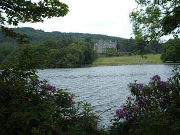
| Castleward Estate & House | Ballyculter | 21: 57/51 | 1km W of Strangford town;click here to see its location on a townland map; click here to see a photo and more information |
.
|
| Castlewellan | Kilmegan | 29: 33/36 | a market town and townland of 737 acres; 10km SW of Downpatrick;click here for a photo and more information; click here to see its location on a townland map; means ' MacQuillan's Castle' | . |
| Castlewellan Castle | Kilmegan | . | large house & estate of 886 acres near Castlewellan ; owned by Earl Annesley in 1863 ; click here for a photo |
GV
|
| Castlewellan Cottage | Kilmegan | . | on the Annesley demesne; residence of Lord Annesley in 1836; the servants donated 7 shillings to Newcastle storm victims 28 Jan 1834* |
V3 p 56, 58 OSM ; DR
|
| Castlewellan Lake | Kilmegan | 29: 32/37 | large lake in Annesley Demesne, 2km NW of Castlewellan |
V3 p 56 OSM
|
| Castlewellan Lodge | Kilmegan | . | residence of Right Hon. Earl of Annesley in 1846 |
POD
|
| Castlewilliam | Killyleagh | 21: 52/51 | 2km S of Killyleagh, near Strangford Lough | . |
| Cathedral Cottage | Down | . | in Downpatrick; residence of Mary Elizabeth Bell in 1871 |
MID p3
|
| Cathedral Hill | Down | . | in Downpatrick; an early hill fort then site of Downpatrick Cathedral |
LR 2007 p8
|
| Catherine Lodge | Warrenpoint | . | a house & small garden in Seaview , Warrenpoint ,leased by Joseph Mayne in 1863 from Roger Hall ; residence of Joseph Mayne in 1886 |
GV ; POD
|
| Catherine Quay | Ballyculter | . | in Strangford Lough; serviced Old Court estate |
Inv 2001 p 41
|
| Catherwoods Fort | Comber | 20; 38/68 | ancient rath ; SW of Ballykeel townland | . |
| Cattogs/ Cottags | Comber | . | a townland 2km SE of Comber; 364 acres;click here to see its location on a townland map; the proprietor in 1795 was Andrew Maxwell; in 1831 there were 89 males & 105 females living in this townland; one windmill in 1836; proprietor in 1836 was the Marquis of Londonderry & his agent was Mr. J. Andrews of Comber; farms were from 5 - 20 acres; rent was 25-28 shillings per acre; of middling quality;there are some ancient stones called the Altar , there are 5 which are 6 feet high |
UJA; V7 p35, 37, 39, 42,44 OSM
|
| Cattogs House | Comber | . | house & farm state of 66 acres; just past Carnasue on the Killinchy road; the proprietor in 1795 was Andrew Maxwell; leased by James McKee in 1863 from Marquis of Londonderry; residence of David Munn in 1899 |
UJA; POD; GV; NDM p69
|
| Caunndarah | Loughinisland | . | mentioned in 1659 census | SP |
| Causeway (The) | Magherdrool | 20: 37/48 | farm on Ballynahinch river,5km S of Ballynahinch | . |
| Causeway Water Bridge | Kilkeel | . | over the Causeway which separates the parishes of Kilkeel & Kilbroney; on the orad between Rostrevor & Kilkeel; a plain, rough structre of unhewn stone with parapets 18 feet broad and 110 feet long; 2 arches |
V3 p 52 OSM
|
| Cavan Cauan |
Clonduff- part | . | a townland of 180 acres; owned by trustees Hon. Robert Meade in 1863; (see below) |
PNNI V3 p 84; GV ; TC p19
|
| Cavan | Drumballyroney- part | . | 1km SE of Rathfriland; 213 acres: click here to see its location on a townland map; means ' a round dry hill'; hill 110 ft; proprietor Sharman Crawford Esq.in 1836;old leases were 10-20 shillings an acre; new leases 40-50 shillings an acre; owned mainly by trustees Hon. Robert Meade in 1863; mostly small farms with the largest being 7 acres; Lord Annesley's bailiff threatened 4 Dec 1880 | V3 p18 OSM; DR; GV; PNNI V6 p 160 |
| Cavan Cottage | Drumballyroney | . | 1km E of Rathfriland |
old b/w map E11
|
| Cavan / Cavancorr | Saul | . | a house cluster in Ballintogher townland | PE |
| Cave Glen | Dundonald | . | an ancient souterrain used by smugglers; on Moor Park farm | TMUOP p54 |
| Cave Hill | Annaclone | . | hill, 6km SE of Loughbrickland; has a well inside; a meeting point for the Magebnnnis clan |
old b/w map F8; PNNI V6 p 66
|
| Cavendish House | Holywood | . | in Victoria Rd, Holywood; residence of Thomas McKee in 1902 | POD |
| Cavin Hill | Newry | . | residence of John & Mary Coffey in 1911 |
OFN p 144
|
| Cedars (The) | Knockbreda | . | corner of Knock & Kings Roads; built by William McLeish c. 1880; residence of Misses McTear in 1902 | OS map 1902 5.09; POD |
| Central Bar | Dundonald | . | at the crossroads; public house now the Elk; b/w photo available c. 1910; proprietor in 1902 was Mrs Herron |
TMUOPp173; POD
|
| Centre Hill | Down | 21: 51/42 | hill ;4km SE of Downpatrick | . |
| Central Hotel | Seapatrick | . | in Bridge St, Banbridge; proprietor in 1910 was R. Duff |
POD
|
| Central Temperance Hotel | Kilcoo | . | on the Promenade in Newcastle c. 1906 |
MO 17/5/2006
|
| Ceobane | Newry | . | alternate spelling for Crobane in 1659 census |
PNNI V1 p 17
|
| Cervery | Aghaderg | . | spelling for Creevy on Rent Roll of 1692 |
PNNI V6 p 31
|
| Chain Rocks | Bangor | 15:61/86 | SE rocks on Mew Island | . |
| Chanderies Islands | Grey Abbey | 21: 54/68 | in Strangford Lough, 2km W of Grey Abbey town; means' gravelly place' |
PNNI V2 p 210.
|
| Chapel Bay | Bangor | 15:59/83 | southern bay on Copeland Island | . |
| Chapel Field | Inishargy | . | site of an ancient church , east of Kircubbin town |
O'L V1 p 427 |
| Chappel Hill | Down | . | near John Street Downpatrick; site of Ancient Priory | O'L V1 p 254 |
| Chapel Hill | Dundonald | . | in Carrowreagh townland; site of ancient church & graveyard | TMUOP p46 |
| Chapel Island | Ballyculter | 21: 56/51 | in Strangford Lough, just offshore near Templecormick; ruined church here ; owned by Mr Aynsworth in 1836; the ruins measure 45 x 24 feet with the door to the north, a cemetery & holy well nearby; inhabited in 1802 by Michael Crickard & family | V17 p 31 OSM; O'L V1 p 218; O'L V1 p 441; Inv 2007 p48; Inv 2010 p53; Inv 2011 p25 |
| Chapel Island | Grey Abbey | 21: 55/68 | 25 acres; large island in Strangford Lough adjacent to Grey Abbey town;off Gordonall townland; an ancient chapel here; boating accident 4 drowned from Mountstewart estate 11 Apr 1900 |
V7 page 68 OSM : DR ; PNNI V2 p 210
|
| Chapel Lodge | Kilcoo | . | a house in Newcadstle; residence of Miss Westerman in 1910 |
POD
|
| Chapeltown | Dunsford | 21: 56/40 | village; 2km NE of Ardglass | . |
| Chappellenbegge | Grey Abbey | Ancient townland in 17th century in East Down; possibly Chapel Island | V17 p 123 OSM | |
| Charity Bridge | Drumbo | 20: 36/67 | over Purdys Burn between Newtownbreda & Carryduff | . |
| Charleville | Knockbreda | 15:37/71 | house & 19 acres in Cregagh townland; ; just S of Castlereagh; residence of Charles Brett Esq in 1758; the proprietor in 1795 was Charles brett; residence of Thomas McConnell in 1852; leased by David McConnell in 1863 from Marquis of Downshire |
MIs; UJA; POD; GV ; M13/24 CBSA
|
| Charleville | Seapatrick | . | the proprietor in 1795 was James C. Mulligan ; residence of J.C. Mulligan in 1824 |
UJA; POD
|
| Charleys Bay | Kilkeel | 29: 26/11 | at the entrance to Carlingford Lough, near Cranfield Point | . |
| Checker Hill | Newry | . | near Newry; residence of Thomas M. Palmer in 1861 |
PR
|
| Chelsea | Bangor | . | in Donaghadee Rd , Bangor; residence of John Currie in 1902 |
POD
|
| Chenawley | Seapatrick | . | near Banbridge; residence of John Walsh in 1852 | POD |
| Chequer Hill | Seapatrick | . | just E of Banbridge |
V12 p 2 OSM
|
| Cherrydene | Knockbreda | . | villa in Cherryvalley Rd, Knock; residence of Alexander Morrison in 1902 | POD; OS map 1902 5.09 ; ACC p7(map), 11 |
| Cherry Hill | Moira | 20: 12/60 | 3km W of Moira | . |
| Cherryhurst | Knockbreda | . | in Cherryvalley Rd, Knock; residence of Jessie Harding in 1902 | POD |
| Cherryvale | Killaney | 20: 35/61 | S of Boardmills townland & E of Bresagh townland | . |
| Cherryvale | Knockbreda | . | farm; 1km N of Newtownbreda; residence of James Steward before 1863 |
old b/w map Q6; Limerick Chronicle
|
| Cherryvale Cottages | Knockbreda | . | in 1-5 Gilnahirk Rd, Knock; a row of three residences built 1898 ; b/w photo available | POD 1902 ; ACC p25,40 |
| Cherryvale | Magheradrool | . | farm; 2km S of Ballynahinch |
old b/w map M10
|
| Cherryvalley | Comber | 21: 47/69 | a townland 2km E of Comber near Comber River's outlet to Strangford Lough; 354 acres;click here to see its location on a townland map; in 1831 there were 73 males & 79 females living in this townland; proprietor in 1836 was Delacherois Crommelin & he acted as his own agent; farms were from 40-40 acres; good land; rent was 35-40 shillings; railway line here in 1863; destructive fire 20 Sep 1890 |
V7 p 37, 39, 42, 122 OSM; old b/w map R8; GV; NC
|
| Cherryvalley House | Comber | . | residence of Robert McDowell in 1899 & 1912 |
POD
|
| Cherryvalley | Knockbreda | . | modern name for Knock village c. 1920s |
ACC
|
| Cherryvalley Cottages | Knockbreda | . | 7-13 Gilnahirk Rd, Cherryvalley; a row of 4 cottages built 1920s |
ACC p25
|
| Cherryvalley | Moira | 20: 17/59 | farm; 3km SE of Moira | |
| Cherryville Cottages | Knockbreda | . | in Kings Rd, Belfast ; residence of J. McKee in 1902 | POD |
| Chesnut House | Newry | . | in Monaghan Street; residence of Mrs. Ellen Dixon in 1881 |
POD
|
| Chester | Holywood | . | house & yard in Holywood townland , owned by John Burgoyne in 1863 but unoccupied | GV |
| Chester Cottage | Holywood | . | house & garden in Ballymisert townland; ;leased by Rev. James Speers in 1863 from rep. Samuel Boyle | GV |
| Chestnuts | Seapatrick | 20: 13/49 | farm; 5 km N of Banbridge | |
| Chievely | Knockbreda | . | in Kings Rd, East Belfast ; residence of Mrs Johnston in 1902 | POD |
| Chimney Rocks | Kilclief | . | just off the shore; photo available |
Inv 2011 p32
|
| Chimney Rock Mountain | Kilcoo | 29: 36/26 | part of the Mourne Mountains; 6km S of Newcastle |
NWAG p 39 ; PNNI v3 p 129
|
| Chinauley | Seapatrick | . | a house & estate in Ballyeevy townland; residence of John Welsh, newspaper editor in 1843 & 1852 ; owned by represenatives of Eliza Walsh in 1876 with 30 acres; residence of William Wadsworth in 1898 | PNNI V6 p 323; POD; LOI; OFB p151 |
| Chinaville | Bangor | . | in Princetown Rd, Bangor; a duplex ; residence of W. McLetchie & Edward Walkingtonin 1901 |
OS map 2.05 1902; POD
|
| Chipps Corner | Garvaghy | . | in Ballooly townland; farms of Fitzpatrick families here | PNNI V6 p 190, 207 |
| Chiselhurst | Dundonald | . | residence of John Kemmitt in 1902 | POD |
| Choud Castle | Ardglass | . | see under Cowd Castle | . |
| Chreyduffe | Loughinisland | . | mentioned in 1659 census for Loughinisland; see Creeghduff | S P |
| Chrome Hill | Lambeg | . | house on River Lagan; just N of Lambeg village; original house built 1600s as a modest factory owner's house by Dutch settler, Abraham Wolfenden; also known as Waterside, Harmony Hill & Lambeg House; remodelled in 1750 by Abraham's grandson Richard; house bought by Richard Niven in 1830 & renamed Chrome Hill to commemorate the discovery of bi-chromates for textile prontinmg; sold to Robert McKinstry in 1967 (b/w photo available) | old b/w map O6; LR 2016 p66-67 |
| Church Ballee | Ballee | . | a townland 5km km NW of Ardglass town; click here to see its location on a townland map; owned by the Southwell Estate and leased to Mr. Charles Johnston in 1752; Church of Ireland & Seceeding Presbyterian church here & school here in 1836; owned by Lord De Clifford; leased by Rev. William Smith then given to his son-in-law Rev. Mr Johnston whose descendent Mt. Johnston of London was in possession of the lease in 1836 | V17 p 21, 22, 23 OSM; LM 1991 p25; GIPR; GIC; O'L V1 p 308 |
| Church Farm | Hillsborough | 20: 21/58 | farm; in Taughblane townland | . |
| Churchfield House | Holywood | . | house & 3 acres in Ballykeel townland; residence of Mrs Suffern in 1852; leased by Agnes Suffern in 1863 ; owned by Matthew McMullan with 4 acres in 1876; residence of McMullan family c. 1875 & Mathew McMullan in 1900 |
POD; GV; LOI; MIs; HPA p132
|
| Church Hill | Holywood | . | residence of G.F. Trimblein 1910 | POD |
| Church Hill | Saul | 21: 52/48 | hill ;near Downpatrick to Strangford road, Raholp | . |
| Churchill | Maghera | . | house ; residence of Miss Small in 1910 & John Waring Bassett in 1922 | POD |
| Church Island | Tullynakill | . | alternate name for Mahee Island |
O'L V1 p 441
|
| Church Moyley | Saul | . | in Raholp townland; name of an ancient Catholic chapel; measured 33 x 21 feet, some walls still 12 feet high, made of yellow clay, cemetery nearby |
O'L V1 p 220 & B p 23
|
| Church Park | Bright | . | in Erenagh townland; site of an ancient Catholic chapel |
O'L V1 p 139, 155
|
| Church Quarter | Dundonald | . | a townland just S of Dundonald town; 123 acres; click here to see its location on a townland map; its old name was Ballydundonnell meaning 'Domnal's Fort'; in 1659 there were 6 English/Scots & 3 Irish families; proprietor Rev. Mr. Cleland who acted as his own agent; good quality land; school attached to the Presbyterian meeting-house in 1836 ; a Church of Ireland & Presbyterian a church here in 1834; public works program instigated for famine relief 27 May 1848 with road upgrades from Wallace's Inn Churchquarter to Ballyoran; railway line here in 1863 |
V7 p24, 41 ,64, 66 OSM;TMUOP p 75, 127, 231; FCD s2
p 9; GV
|
| Church Quarter | Maghera | . | let to Rev. W. Annesley in 1833 | O'L B p 20 |
| Churchtown | Ballyculter | 21: 57/47 | small village on the Killough Road, 3km SW of Strangford town; parish church here; click here for a photo | Inv 1997 p 46 |
| Churchview | Annaclone | 20: 15/40 | farm; 4km W of Annaclone village | . |
| Church View | Annahilt | 20: 30/57 | farm; 1km NE of Annahilt village | . |
| Church View | Holywood | . | owned by James Geddis with 1 acre in 1876; residence of Robert & Annie Boyd in 1887 & Capt. Alexander McLelland & W.H. Weir in 1910 |
LOI;PR; POD
|
| Church Wall(s) | Ballee | . |
in Loughmoney townland; site of an ancient Catholic
cemetery in two fields; lease sold by Hugh O'Neill to Robert H. Smith
then to Mr. Lambert of Dunlady
|
O'L V1 p 223,247, 308 |
| Churn Rock | Bright | . |
in Ardglass Harbour-; removal 1 Nov 1879
|
DR |